|
|
Ulster County
By H. Schile |
|
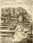
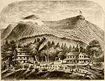
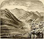
Bishop Falls
Esopus Creek, with High Point behind
|
Bishop Falls
The Bishop Falls, near Olive City, are very beautiful, and are constantly visited by summer boarders. Of course in dry weather you cannot expect to see as great a fall as in other seasons of the year. This place possesses splendid facilities for bathing and boating, as may be seen from the picture, which also represents the mighty rocks on either side of the waterfall.d ghosts were dancing around them.
The picture represents the creek beneath Bishop Falls, as viewed on a pleasant summer's eve. It is taken from a high point in front, looking up the creek. In the background is seen High Point. The picture will be easily recognized by all who have ever boarded at Mr. Lasher's or thereabout. It is a popular summer resort, and a favorite spot for boarders, in consequence of its bathing and boating facilities. Those who have never visited this lovely spot, ought not to neglect to do so at their earliest opportunity.
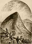
High Point
This magnificent mountain, which is about 3300 feet high, is the most eagerly sought for by all summer boarders.
It thoroughly deserves its popularity, for it is a beautiful spot. On the top of this mountain there is a wide expanse of level ground, which at one side is abruptly terminated by a yawning abyss. Another remarkable feature is also connected with this mountain. Near the summit, and on level ground, there lies a rock which has a triangular chasm. From this aperture, the bright waters of a rivulet issue; but this spring is subject to the laws of the ebb and flow of the tide. Many, who have at one hour of the day enjoyed the freshness of this spring, a little later on, have found it dried up. At the time of their ebb and flow, the waters of this spring have a disagreeable sulphur taste. This inexplicable phenomenon naturally excites wonder and amazement. |
|
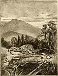
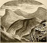
Grave-Yard, Ulster County
High Point In The Distance |
A Graveyard in Ulster County.
Throughout the Catskill Mountains one can find many such graveyards as the one here shown; but this is the most neglected home of the dead I have found in Ulster County. On some barren spot of the mountain side, we can discover traces of former graveyards, but the constant slidings of the earth have destroyed them; and who knows but what some wild beast or another has gnawed the bones of those consigned to their everlasting sleep? The farmers, in burying their dead, usually select the most accessible spots; and as is often the case when the farm changes ownership, the sanctity of the plot, where dear ones lie buried, is often lost; the place is neglected, and the graveyard, which we are wont to look upon with reverential awe, and to preserve in good order, becomes a wretched Potter's field. Such is the picture represented here. In the back-ground rises High Point. When I first looked upon this and other kindred places, I could not help thinking that the dead buried there, were put there not only to their eternal rest, but also to be eternally forgotten.
|
|
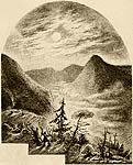
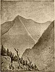
Entrance Into The Catskill Mountains |
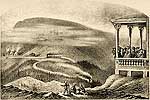
Entrance Into The Catskill Mountains
The picture shows the entrance into the Catskill Mountains. To the left is seen the base of High Point; Simon's Point lies to the right, while in the background rises Cross Mountain. The scene represents a bright moonlight night, while the deep valley beneath is shrouded in a misty fog. It is but a distance of four miles to Shokan, where you arrive at the foot of the grandest of the Catskill Mountains. Here the railway turns to the
right, but the pedestrian follows the opposite direction, until he reaches the valley known as Bushkill Vale. Continuing the road to the left you will find yourself in that portion of the valley, in the rear of High Point. There is also a splendid fishing pond situated here.
|
|
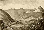
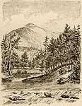
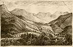
Panorama Near Bushkill |
Panorama Near Bushkill
This scene represents the chain of mountains, which begin at Bushkill, and which constitute what is known as Ketchum Hollow. I have taken the picture from a point of the mountain just opposite Weidner's Boarding-house, on the mountain road from Shokan to Mount Pleasant. To the artist who is desirous, of making an elaborate drawing of the scenery, this is the most advantageous point as well as the most accessible. This neighborhood has a lovely situation at the base of the High Mountains: for both tourists and boarders who appreciate the beauty of nature acknowledge that they could not have selected a pleasanter place than this. In the vicinity and even further back among the mountains, a number of farmers live. Another boarding-house is represented in the picture. The first Mountain peaks are Sam's Point, Blackberry Point, Cross Mountain, Wittenberg Cornell and Hanover Mountains. At the left extends the base of High Point, and the beautiful valley with the charming trout creek. It is somewhat remarkable that just at this point, only four miles from Shokan, all the high mountains commence, thus affording a scene which in its beauty and grandeur cannot be surpassed by any in Switzerland.
Ketchum Hollow
In the neighborhood of Shokan, towards the left, extends that magnificent valley, Ketchum Hollow, or, as it is called by the farmer, Bushkill. Here we find ourselves at the foot of the highest mountains: High Point Mountain 3300 feet high; South Mountain, Hanover Mountain, and Cornell Mountain 3900 feet high; Wittenberg Mountain, 3824 feet high; Cross Mountain, Simon's Point, Friday Mountain, and the Blackberry Point.
All of these mountains are so very steep that it is impossible to ascend them from their front.
|
|
Mount Pleasant - Elevation 690 ft.
Catholic Church On The Road To Shandaken
La Dew Farm |
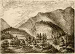
Mount Pleasant
This represents the south-eastern side of Mount Pleasant, taken at Little Shandaken.
The view shows the lower portion of the valley, and extends over Esopus Creek. To the
left we, see the little church, and quite near by, the boarding-house of Mrs. Lamson, which is surrounded by shady trees. This house is well situated upon a rising hilly ground, so that in the summer it is always cool and pleasant. Little Shandaken possesses the very
best conveniences. Its roads and pathways are unsurpassed; such as the walk from Little Shandaken up to Cooper Lake, and thence to the Mead House, to the Twin Mountains, Echo Lake, and the Overlook Mountain House. Any of these walks can be accomplished in one day. Whoever desires to enjoy a splendid view, should go from the La Dew Farm, to the La Dew Peak, which we have described above. As soon as he has arrived at the first level piece of ground, he will behold the beautiful valley extending beneath him, at almost every step the view changes. The higher he ascends, the more vast is the scene spread out before him, which he cannot but enthusiastically admire. A beautiful pathway equally adapted for pedestrians, horse-back riders and coaching parties, follows the Esopus Creek as far as the Tremper House. Turning to the left, and crossing the stream, it leads into the Woodland Valley about one mile distant. We have already said that this narrow vale is the nearest way to Wittenberg. A visit to this neighborhood will never be forgotten. At this lower portion of Mount Pleasant, we can distinguish a passage-way for foot-passengers, and from there a beautiful view can be had from Little Shandaken, up to the Overlook; a scene as grand as the inspired imagination of the artist painter could desire ! The other view of Mount Pleasant is on the other hand quite uninteresting. This mountain. closes all entrance into the beautiful valleys.
|
|
View From Mount Pleasant
Mount Cornell - Elevation 3920 ft.
|
View From Mount Pleasant
The picture taken from Mount Pleasant, shows the little Shandaken. We have the whole valley before us, with a fine upward view towards the Overlook. The two houses seen in the midst of the mountains, were formerly called "the Corner," but afterwards, " La dew Farm." This farm is owned by a German named Schumacher, and is one of the very best summer resorts. Being kept in the German style, it is principally patronized by Germans. From the house a pathway leads up to the summit, called at the mountain
"La dew Peak," which can be reached in about one hour and a-half. Before the traveler has gone one hundred yards, he can already enjoy a beautiful view of the valley extending beneath him. We behold High Point immediately in front of us. To the left of High Point, we can see the Shawangunk Mountains and Lake Mahonk. The valley below La dew Peak is little Shandaken and, as represented in the picture, it extends up, to the Overlook Mountain. The Overlook Mountain House, which seems like a little white spot in mid-air, presents indeed, a truly fairy like aspect. From the summit of High Point one can obtain an extensive view over all the surrounding country; on the right is seen Cooper Lake, behind the mountains we can distinguish Kingston and Rondout, the Hudson River, and her far-famed Highlands. A view from Overlook to High Point includes the whole of the beautiful panorama. The Vermont Mountains are visible in all their grandeur. One might suppose them painted in the air. I confess that after all the wonderful phenomena I have witnessed in the Catskills, I am not at all surprised to know that the Dutch and the Indians were accustomed to tell the most charming and wonderful stories regarding their experience in these mountains. At the right, in their full beauty, you can distinguish the highest mountains: Mount Cornell, Wittenberg, Cross, Slide Mountain, the Balsam and the Panther Mountains. Here I enjoyed the most beautiful prospect it was ever my good fortune to behold. I was roaming about in this vicinity, there had been a
terrible snowstorm in the mountains. The sunlight breaking forth caused the clouds to assume a dark grey color as they hung in fragments from the heavens. The change in the illumination produces most wonderful effects: at one side the clouds fly past like ghostly figures, while on the other, they appear brightly illuminated. Looking backwards, towards Chichester, we behold a succession of finely formed mountains, extending, apparently, to Stony Clove, Greene County. La dew Peak, with its magnificent scenery, has hitherto been almost entirely unknown; but lovers of nature could scarcely find brighter and more interesting views, and more peaceful surroundings, than are here enjoyed.
|
|
Entrance Into The Catskill Mountains |
Entrance To Stony Clove
This is at Phoenicia, Ulster County, and passes the Tremper House and the Chichester Chair Factory. The pathway leading into it is well preserved. The valley has a very romantic aspect, and the nearer we approach Stony Clove, it grows steeper and assumes a wilder character. At the beginning of the entrance the view is extremely picturesque. The entrance, being very narrow, is difficult to pass, and reminds one of the Pass of Thermopylae. On the left, the lofty mountains rise like a wall. It is a fearful and wonderful sight to see those monstrous and gigantic rocks towering at a height almost beyond the reach of the human eye! They resemble the Palisades of the Hudson. In the depth, one can see a remarkable foliage, which, winding through the clefts in the
rocks, at last attains a great height. The trees are of the wildest growth, their trunks being covered with green moss and parasites. It is indeed, beyond human power, to give an adequate description of the wilderness of the surrounding country.
The only possible way of ascending the mountain is by the pathway on the right side of it. The clefts in the rocks are unfathomable. Even the sun's rays cannot penetrate to their bottom; and thus we can, even in the midst of summer, find ice and snow in their depths. Foxes, eagles and owls hide in them, and, consequently, this is a favorite place for hunters. A railroad will soon pass through here, and thus before long, this great emblem of civilization will have encroached on this hitherto wild, romantic region. The railway will go from Phoenicia, through Stony Clove to Hunter. Undoubtedly it will secure the most excellent advantages to the summer resorts of Greene County. It is evident that as soon as the iron steam-horse gallops through this country, it will lose all value as a hunting-ground.
Approaching Greene County, the aspects of the mountains change; they become more abrupt and assume the name of Stony Mountains. The other mountains, to the left, break off suddenly, and only the rear portion connects with Hunter Mountain. At this point they reach an elevation of about 4,054 feet. The footpath turns from the right to
left, as before mentioned above, in leaving Ulster County, and the whole appearance of the mountains change. The valleys themselves being somewhat elevated, the mountains appear quite low, though, in reality, they average as high as the others. The way to the right leads to Tannersville; and, from here, Cauterskill Clove and the Catskill Mountain House can be easily reached.
The road to the left leads to the well known Hunter, Greene County; from Hunter to Lexington, and from this latter place, through a beautiful vale, to Westkill.
These roads through Tannersville, Stony Clove and Phoenicia Station on the one side, and through Hunter, Lexington, Westkill, the Notch and Shandaken Station on the other side, are the passes through these mountains, from Ulster and Greene Counties.
|
|
Mount Sheridan, With View Of Shandaken Valley. Elevation 2300 ft.
Mount Sheridan, With View Of Woodland Valley |
Mount Sheridan
Mount Sheridan has an elevation of 2,300 feet, and is twenty-eight miles from Rondout. It can be most easily ascended at a point opposite O'Neil's boarding-house. An excellent view of Shandaken Valley can be obtained from its summit.
Shandaken, which is situated in a deep valley, presents a wild and romantic aspect. It is a small village, whose principle industry consists in a chair factory and a saw-mill. It contains a hotel for summer boarders, known as Lamment's Hotel.
The village lies in the centre of the valley: the most romantic part of the Catskills. The walks here are beautiful beyond description. To the right of the hotel we witness the remarkable change in the appearance of the mountains before alluded to. Pleasant paths traverse the whole valley.
Continuing along the main road, we pass through Deep Notch, which is about seven miles distant from Deo Brothers' summer resort, at Westkill. From the eastern side of Mount Sheridan, (as represented in the other picture), we can obtain a direct view of the Woodland Valley. The scenery in this vale is highly romantic. In the midst of it we behold Mount Wittenberg. Viewed from the front, the mountain appears to have a gable, and, as upon the wall of a fortress, the gable winds itself upwards to the highest point of the mountain, the crest of which appears in the form of a Liberty cap. Viewed from any side, it presents a very remarkable and interesting appearance. Towards the right we see the broad backs of Mount Wittenberg, Cross Mountain, Cornell Mountain and Slide Mountain, all in the same line, and shutting in the valley. All the other mountains are easily reached from here, and ascended without any trouble, with the exception of Slide Mountain, to ascend which, from this side, would be a difficult task. The road to it
is to be found at the. Big Indian. From this place Slide Mountain appears to be quite a distance off, though in reality it is not far. In front and to the right are the Panther and Balsam Mountains.
|
|
Mt. Wittenberg. Elevation 3824 ft.
Slide Mountain In Winter. Elevation 4220 ft.
Winter In Big Indian Valley
View From Piazza Of Grand Hotel |
To The Slide Mountain
The easiest and only route by which to reach this is Big Indian Valley. The traveler can ride in a wagon from Big Indian Station almost to the highest point of the mountain, where one Mr. Dutcher, a farmer, is the guide in this region. The distance from the station to the guide's dwelling is about seven miles, and from here about five miles. This is the highest of all these mountains, though it by no means appears to be so, since it is very long, and connects with the others in the rear. The spectacle here of the rising and setting of the sun is grand. It is beyond the power of words to describe it. From the summit of this mountain, the eye has command of all the country for miles around, and the view seems unlimited. In truth, the picture is one that beggars description.
Passing over the ridge of the mountain, we reach Deep Notch, the source of the Never-sink. The surrounding, being a total wilderness, possesses a romantic beauty. The mystic lore and legends of the Dutch, and of the Indians, seem to have constant inspiration from this locality ; and poetry had ever a much congenial subject in the splendor of the home of the Neversink.
The name, Slide Mountain, is due to the fact that the entire upper portion of the mountain looks as though it had slid downward into the valley. In viewing this mountain, we find the most unmistakable traces of the wanton devastation committed here by the inhabitants. During the last sixty years, the bark of the needle-like foliage in this vicinity has been unscrupulously devastated; and to-day, probably, not a single fine fir-tree can be found, where once the country abounded in countless numbers of them. Every nook and corner of this neighborhood was filled with tanneries; and, not satisfied with this method of ruining the trees, the farmers began a warfare against them by burning them out. They had only intended to burn down a few acres, but, being powerless to control the flames, whole miles of the forest were leveled to the ground, thus depriving the country of its natural wealth. They did not know that in doing so they were robbing themselves, and ruining, with brute force, their own resources. How strange that now nothing but stone-quarries flourish where once healthy vegetation had a home! Now there is a drouth there; wells and springs have dried up, and any one whc has visited that region within the last few years, will bear witness to the many ineffectual attempts to restore the vegetation of the land. Usually, grass-seed is sowed first, so as to make the soil more susceptible to other seed, but all to no purpose; the first heavy storm washes the earth away, and nothing but the naked stones remain. Nature had in vain covered the mountain with foliage.
Whoever wantonly destroys the forest, commits an unpardonable crime!
The science of forestry was unknown to America; otherwise, the condition of the country at the present day would be far different.
Is this always to be so?
What will become of the American forests, if a change for the better is not made at an early day ?
|
|
|
|