|
These mountains belong to the great Appalachian
or Alleghany range of mountains, but are more Alpine than other
portions of this range, the elevated peaks rising higher above the
general range of the summits below them. As elsewhere in these
mountains, the eastern slope of the Catskills is abrupt, precipitous,
and broken, while their western descent is more gentle and gradual.
These eastern slopes are also often in distinct strata, looking like
a succession of extensive and regular terraces, such as are seen
north of the Cauterskill Clove. At the eastern base strata of the Old
Red Sandstone formation are seen, dipping abruptly in towards the
central axis. Then gray slaty sandstones, of hard texture, make up
the most precipitous slopes, except those of the highest summits,
which are capped by the conglomerate of white quartz pebbles. This is
the basis or floor of the coal formation, and is found on the highest
knobs of the Alleghanies. Coal-beds are found directly above this
conglomerate quartz; and, were the Catskill Mountains one hundred
feet or more higher than they are, some of the lowest of the
coal-beds might be found there. Black shales are sometimes met with
among the conglomerate, and seams of anthracite coal a few inches
thick, showing a near approach to carboniferous or coal-bearing
strata or deposits.
The upper Hudson River group of mountains is
partly clay slate, and partly talcose schist, with occasional beds of
limestone, such as are met with between Catskill and the base of the
mountains. The Catskill Red Sandstone is the upper member or portion
of this kind of rocks in this country, and is about three thousand
feet thick. The whole thickness of the system in the United States is
11,750 feet. Between the Dutch church, at the base of the mountains,
and the Rip Van Winkle Glen, there are fifty-seven distinct layers,
or. strata of rock, mostly grit shale, of different colors, and one
hundred and thirty-seven layers in all, up to the summit of the
mountains. From the river to the Mountain House, most of the
different kinds of rocks found in the whole State of New York, of the
depth in all of near four thousand feet, maybe seen. The Catskill
division of rocks has but few minerals in it. Small quantities of
iron, copper, lead, and zinc are extensively found in a particular
kind or layer of rock, in different parts of Greene, Ulster,
Sullivan, and Delaware counties, but nowhere in veins of more than
eighteen inches thick. This rock is generally a calcareous or
limestone conglomerate of breccia or pudding-stone, formed of small
masses of limestone, included in a reddish or brownish paste of the
underlying shale, or slaty rockbed.
Stones, for paving and building' are obtained
in immense quantities from quarries along the base and the eastern
front of the Catskill Mountains, which are transported, by way of the
Hudson River, to all parts of the United States. The strata, or
layers, in which these rocks are found, are from two to fifteen feet
or more in thickness, with slabs of from four or five to one hundred
or more square feet of surface, and from one to six or more inches in
thickness ; often traversed or crossed by joints, or seams,
perpendicular to the surface, as smooth as if cut by a saw, though at
times there is no break or seam in these rocks for one hundred and
fifty feet or more in horizontal length. These quarries are commonly
leased to those who work them, and who sell the stone to large
dealers and shippers, on the banks of the river, from two to five
dollars for each one thousand feet taken from the quarries, being
paid by those who work them. Judge Hasbrouck, of Kingston, for
example, leased his quarries for five dollars for one thousand feet,
each square yard yielding from fifty to seventy square feet, or three
hundred thousand feet to the acre, bringing him in fifteen hundred
dollars per acre; though he gave, a few years since, but a dollar an
acre for the land. Among the largest dealers in stone are the Messrs.
Bigelow, of Malden, on the river, near Saugerties, in Ulster County.
They are brothers of the Hon. John Bigelow, recently United States
Minister at the Court of France. In 1860, it was computed that in
Sullivan , Ulster, Greene, and Albany counties, there were three
million five hundred thousand square feet of flag or paving stones
quarried and sent to market. Much more than this amount must now be
wrought and shipped from these counties annually, to say nothing of
large quantities of brick, made all along the western bank of the
river, and the hydraulic or water-cement manufactured in large
quantities in Ulster County.
At this point it may be well to notice certain
principles and facts connected with the bard, rocky shell or outer
covering of the earth, as made known to us by the science of Geology,
of some of which striking proofs and illustrations are met with in
the Catskill Mountains and the region around. Geologists divide the
rocks on and beneath the surface of the earth into five classes.
First and lowest of these are the primary, or crystalline, which are
in solid, massive, irregular forms, without strata, or layers. The
rocks of this class are granite, sienite, porphyry, trap, and lava.
They have in them no traces or remains of plants or animals, and are
supposed to owe their form, origin and structure to the action of
fire raging and melting beneath them. The second, or Palaeozoic
class, contain the earliest traces of the forms of animals and
plants, were mostly deposited in the ocean, and are some thirty-three
thousand feet, or more than six miles thick, or deep. The third class
are called Secondary rocks, extending from the top of the lower new
red or Permian system to the top of the chalk formation, a depth or
thickness of five thousand feet, or nearly one mile. The Tertiary
strata come next in order; partly solid, but with very different
organic remains from those of the strata below them, with an average
thickness of about two thousand feet, or more than one-third of a
mile. Last and uppermost is Alluvium, or the earth and rocks forming
the surface of our globe, to a depth of two hundred feet or more, and
made up mainly of decayed and decaying animal, mineral and vegetable
matter. The lower or primary rocks, seem to have been forced up
through, and far above, the overlying strata and the level surface of
the earth, by the action of heat below them, so as in many instances
to form the summits of lofty mountains ; and, in the case of lava,
still to overflow these mountains. Granite seems to have been thus
forced up first, then sienite and porphyry from below it; after these
the various kinds of trap-rock, from below the porphyry; and last the
lava, which still rises from beneath all the rest. Geologists claim
that at the end of the Tertiary period of deposit, when the alluvial
mass began to be for ed there was a long, dreary winter of ice and
snow, which extended far down towards the equator, when mighty
glaciers and masses of ice, loaded on their lower surface with vast
rocks, were borne far and wide along the surface of the earth,
crushing and levelling down hills, removing the summits of lofty
mountains, and deeply ploughing along and marking their upper heights
and sides, thus preparing for the surface of the earth a covering
which would, in after times, aid in furnishing food for man and
beast. The extent of this ploughing and grinding movement is
dedetermined by the limits of the crushed and broken ruins it has
left behind it.
There are evident traces of the action of these
glacier along the valleys of the Penobscot, the Connecticut, the
Hudson, the Mohawk, and the Susquehanna rivers. On the Catskill
Mountains, as we learn from Ramsey, the glacial scratches and grooves
are numerous, and extend up to where the Mountain House stands,
nearly three thousand feet above the level of the sea. All but a few
of the highest of these grooves run from north to south along the
flanks of the precipices in the direction of the Hudson River Valley,
and not from west to east, down the slope of the mountain. The
principal grooves run between south twenty-two degrees east, and
south, fifty-five west. These variations seem to be connected with
bends and other irregularities, in the direction of the great eastern
wall of the mountains. The course south, fifty-five degrees west, is
found at the top, near the Mountain House ; while at the summit of
the water-shed, there are numerous main grooves passing across the
mountain at right angles to most of those observed in ascending it.
As freezing water expands, or fills more space
before, after reaching thirty-nine and one-half degrees, it thus
opens and widens seams in rocks, rends them asunder, and rolls them
down precipices; while in soft, porous rocks, it crumbles off the
surface and decomposes them. Beneath the high cliffs, and all along
the base of the Catskill and other high mountains, are immense masses
of these detached and decomposed rocks. Much of the soil, on large
portions of the surface of the earth, has come from this process,
which, in icy regions, is constantly going on. Glaciers, or immense
moving masses of ice and snow, descend by their own weight and the
pressure of the mass above them along valleys, from snow-covered
mountains, and are from two thousand to five thousand feet deep,
being fed by the snow and frozen mist of regions of perpetual snow
and ice. They reach from five thousand to seven thousand five hundred
feet, or from a mile to a mile and a half below the line of perpetual
snow ; their depth or thickness being such that the heat of summer
does not melt them.
It is a singular fact connected with the
upheaving of some of the lower and earlier strata which form the
crust of the earth, that remains of various kinds of animals, which
grew in the depths of the ocean, are found in the Alps, from six
thousand to eight thousand, and in the Andes fourteen thousand, feet
above the level of the sea; and these not brought there by any sudden
overflow of the waters of the great deep, but deposited for ages in
beds of great thickness; so that these remains must have been forced
up from below by some mighty power beneath them, or else the sea must
have retired from its former level. Saussure says that the summit of
Mount Blanc, which is thirteen thousand feet high, must have been two
leagues below the level of the sea, and that the granite formed there
was afterwards raised. The peaks of the Andes are mostly volcanic, no
granite having been found there higher than eleven thousand five
hundred feet. Were it not for the abundant remains of plants and
animals in the different strata and systems of rocks, we could not be
sure that all rocks were not of one and the same age and date. The
beds of granite, which in mountain peaks and ranges are nearly
vertical or perpendicular, owing to their having been forced up from
below, must have become solid before they were thus raised up.
More than thirty years since, Professor
Agassiz, now of Cambridge, Massachusetts, and Professor Guyot, of
Princeton, New Jersey, engaged in minute and extensive observations
among the Alps, near which they were born, with a view to determine
the movements and agency of glaciers across the valleys of
Switzerland between one mountain range and another ; the result of
their investigations and those of others, there and elsewhere, having
thus far been in part as follows, as stated by Professor Agassiz :
"That there was a time, immediately preceding the state of
things which now prevails upon the earth, during which the whole
surface of the globe was covered by masses of ice as thick, as
extensive, as compact as those which now overspread the Arctic
regions ; and perhaps we shall see, that even where the tropical sun
now shines, there was at one time a field of ice extending over the
Valley of the Amazon toward the Atlantic, and covering, it may be,
the sea to such an extent, that the question may be fairly asked,
whether there was not open water at the equator. Thus, by intense
cold, life must have been banished from the surface of the earth, so
as to prepare it for the new creation which now exists upon it ; this
severe winter having put an end to all living beings on the surface
of the globe."
As glaciers are not solid ice, but snow,
penetrated by water and but partially frozen, hence they move slowly
down the sides oil mountains, at the rate of from twenty to two
hundred and fifty feet, or more, in a year; the centre of a glacier
being higher than its sides, and moving faster, in as much as the
sides are melted by the heat of the rocks and cliffs against which
they press; and from this cause also their motion is made slower by
means of friction. As also the heat of the sun passes freely through
the glaciers, the rocks under them, by this heat, shape for
themselves a mould, or firm resting-place in the mass above them, and
are borne onwards by the movement of the glaciers, so as to smoothly
wear, or deeply furrow the surface of rocks and mountains over which
they move. Hence "the lower surface of the glaciers is like a
file, thickly set with diamonds, constantly grooving, furrowing,
polishing or scratching the surface over which it moves,"
writing or deeply engraving the record of their deeds of violence on
the region over which they pass. The course of glaciers is traced,
not only by the marks just noticed, but by the rocks they have
carried along with them, and left by the way ; so that thus there is
evidence that the Valley of Switzerland, between the Jura Mountains
and the Alps, was once covered to the depth of three thousand feet.
On visiting Great Britain, Ireland, and the
United States, and more recently the Valley of the Amazon, Professor
Agassiz found traces of the action of glaciers extending down to the
sea-coast, and reaching as far as South Carolina, or to thirty-two
degrees of north latitude. In Maine he was satisfied, by observation,
that glaciers there must have been six thousand feet, or more than
one mile in thickness ; and he is now convinced that we have had
snow-fields on this continent, covering the land to the depth of
twelve thousand or thirteen thousand feet. The difficulty urged
against the moving of glaciers on level ground is met by the fact,
that they do thus move in Greenland, that there are traces of such
motion in our own country, and that the rapidly accumulating masses
of snow in the colder latitudes would create a pressure towards the
warmer regions, where the melting of the snow would open a way for
the pressure in the rear.
By extensive and minute observation, Professor
Agassiz is satisfied that the whole valley of the Amazon was once
occupied by a stupendous glacier, coming down from the Andes, and
reaching the Atlantic ; and that all the loose materials which now
form the bottom of the valley of the Amazon, were ground down by that
ice, and scattered evenly over the whole land, as the valley of the
Rhine is covered with mud and clay, once ground in the Alps, and
brought down by the waters from the glaciers in that region.
To the views of Professor Agassiz, with regard
to the utter destruction of animal and vegetable life, just before
the creation of the animals and plants now on the face of the earth,
it is urged, that we now find, in England for example, more than
nine-tenths, or ninety-six per cent. of the species which existed
during the latest tertiary period, and before the glacial. Hence it
follows, that, if all these species were destroyed by the universal
reign of snow and ice, they must, of course, have been re-created at
the beginning of the present order of things; an event not impossible
surely, how improbable soever it might seem to have been.
The streams from the eastern slope of the
Catskill Mountains soon reach the Hudson, while those from the west
flow into the Mohawk and Delaware rivers.
The principal products of Greene County,
besides stone, are pressed hay, which is shipped in large quantities,
Indiancorn, rye, buckwheat, oats, potatoes, butter, and cheese. The
principal manufactured articles are brick, paper, cotton and woollen
goods, and formerly large quantities of leather, before the mountains
were stripped of their widespread growth of hemlock bark. Thirty or
forty years ago, Greene County made more leather than all the State
of New York besides.
About 1817, when improved methods of tanning
leather were discovered, numerous tanneries were established among
the Catskill Mountains. The Palens of Palensville, a family of much
intelligence, worth, and successful business enterprise, built a
large tannery at the lower entrance of Cauterskill Clove, near the
commencement of the present century, earlier than the date named
above. In July, 1717, Colonel William W. Edwards and his son, of the
same name, removed from North Hampton, Massachusetts, to the village
of Hunter, and erected there the first extensive tannery in the
State, in which what was then the new mode of tanning was adopted;
and the family still have a summer residence there. Colonel Zadoc
Pratt, from whom Prattsville, formed from Windham, in 1833, was
named, tanned two million sides of sole-leather there, besides being
extensively and successfully engaged in agricultural pursuits. He has
been a liberal patron of the different churches in the village where
he resides, and of other worthy objects; was a member of Congress ;
and his bust, with that of his noble and patriotic son, also a large
manufacturer of leather, a brave officer in our late war, and a
victim of it, has been cut in the solid rock of a high cliff which
overhangs the village. There are the decayed and decaying ruins of
what was once a busy and thrifty village of tanners in the wild
ravine of the Cauterskill Clove, nearly opposite the Laurel House;
and this place, and the region above it, once known as Tannersville,
with the Tanner's Bank in Catskill, are memorials of a business which
did much to increase the population and wealth of the county, and to
clothe with productive fertility the hillsides and mountains far and
wide around.
Before the Erie Canal was opened Catskill
shared in the trade of Southern and Western New York as far as Lake
Erie, as also of Northern Pennsylvania; but the Canal, with the Erie,
Hudson River, and Harlem Railroads, by turning travel and trade in
other directions, have seriously affected the condition and prospects
of the place. Catskill was once a great wheat-market; and at the
Falls of the Catskill, three miles west of the village, were the most
extensive flouring-mills in the State. |
|
The great Hardenburgh patent, granted to
Johannes Hardenburgh, of Kingston, Ulster County, by Queen Anne,
April 10, 1708, who had previously purchased the land of the Indians,
covered nearly all of Greene County lying west of the mountains, with
large portions of adjoining counties. The north line of this grant
commenced at the lakes just back of the Mountain House, the head
waters of the Cauterskill, and ran northwest to the head waters of
the west branch of Delaware River, in Stamford, Delaware County.
Stephen Day, from Wallingford, Connecticut, early bought a tract,
embracing a large part of the old town of Windham, now made up of
Windham, Ashland, Jewett, and a part of Lexington and Hunter. This
region was extensively settled by emigrants from Connecticut, as was
also the town of Durham, north of the mountains, and their
descendants retain the moral and religious traits, and have much of
the industry, economy, business tact, shrewdness and success, which
are met with in "the Land of Steady Habits." At Red Falls,
on Batavia Hill, in Prattsville, Burton J. Morss, Esq., has a large
manufactory of cotton cloth, as also another in Gilboa, in Schoharie
County, while his extensive farms, and his large herds of cattle, of
the best English breeds, have made him the benefactor of the region
where he lives, and have caused him to be widely known in the State
as a man of uncommon energy, enterprise, intelligence and worth.
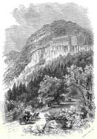
The Mountain House is on the line of the town
of Hunter, while the Laurel House, the Haines House, Gray's, and some
of the wildest ravines and the loftiest peaks of the Catskills, are
also in Hunter. Samuel, Elisha, and John Haines, and Gershom Griffin,
early came to Hunter by the way of Kingston and Mink Hollow, to the
south and east, and were discovered there, a year or two afterwards
by some Dutchmen, who came there from the east side of the mountain
hunting bears. They were followed in 1786 by a number of Shays'
followers, from Massachusetts, who, on their defeat by the troops
under General Lincoln, fled there for safety. Shays himself lived in
Schoharie County, after the suppression of the insurrection which
bears his name, and died in 1825.
The portion of Greene County, between the
mountains and Hudson River, was much of it early held by a few large
proprietors, who bought their lands of the Indians, and then obtained
patents, or grants from the monarchs of Great Britain, confirming
their claims to these lands, and giving them a full legal title to
them. Lindsey's patent, which was an early one, dating back in the
seventeenth century, covered seven hundred or eight hundred acres,
where the village of Catskill now is, and in the country round. The
Loverage patent of about one thousand acres embraced the Imbought
below Catskill, and was bounded east by Hudson River, and north and
west by Cauterskill and Catskill creeks ; its south line being near
where the Gardiners live, in the Imbought. Beekman's patent was in
Kiskatom, from where Kiskatom Creek enters into the Cauterskill,
north to the Catskill patent line, and the Greene patent, to near
Neely Lawrence's; embracing lands owned by Abraham Ramsen and others,
along the fertile valley of Kiskatom and a little east of it.
Greene's patent covered a large tract along the eastern base of the
mountains, and extending west up their slope and over their summits.
In the year 1677, Sylvester Salisbury, who came
to this country with Governor Nicoll and had command of Fort Albany,
and Martin G. Bergen, purchased from the Indians their title to a
large tract of land. For this a patent was given in 1688; and, as
Salisbury was then dead, his wife, Elizabeth, held the land with Van
Bergen. Salisbury had rendered meritorious service in the British
army. This tract embraced five flats, on both sides of the Catskill
Creek, near Leeds, and above the lands of Elder Degouer Geritsen,
since known as the Van Vechten farm, which was first occupied by that
family in 1681. From this grant the Brunk farm also was excepted, a
tract of about one hundred acres, the house having been just back of
where John Van Vechten, Esq., of Leeds, now lives; who, as a surveyor
of long and wide experience, has given me much valuable information
with regard to the early history of the county, of which he was a
native, and now at the age of fourscore remembering the time when
there were but five houses where the village of Catskill now is.
From the flats, spoken of above as a center,
this grant of Salisbury and Van Bergen extended four miles east,
west, north, and south, exclusive of the farms just spoken of, and of
the lands covered by the earlier patents already noticed. Its
southern bound was just below the covered bridge, near Zechariah
Dederick's ; on the west it reached to the eastern line of the farm
of the late John R. Linzey, on the side of the mountain, and embraced
nearly the whole of the town of Athens, and a part of Cairo and Coxsackie.
Greene County contains six hundred and
eighty-six square miles; its population is 15,591 males, and 15,546
females, a difference of only forty-five in a population of 31,137,
and this too in favor of males, a state of things very uncommon in
the older portions of our Union. Among its annual products are
480,795 bushels of grain, 116,871 bushels of potatoes, 192,814
bushels of apples, 1,191,930 pounds of butter, and 21,317 pounds of cheese.
|