A JUNE JAUNT
WITH SOME WANDERINGS IN THE FOOTSTEPS
OF WASHINGTON, BRADDOCK,
AND THE EARLY PIONEERS.
Also Cumberland and Piedmont Coal Region
by BRANTZ MAYER—Harper's Monthly—April,
1857
 WHEN Madame
de Sevigné exclaimed, in the joy of her heart, "A
journey to make, and Paris at the end of it!" she uttered
the sentiment of a thorough-paced woman of the world, tired to
death of those dreary old chateaus, which; like so many architectural
poplars, break the monotonous levels of France, with their circular
towers and sugar-loaf spires.
WHEN Madame
de Sevigné exclaimed, in the joy of her heart, "A
journey to make, and Paris at the end of it!" she uttered
the sentiment of a thorough-paced woman of the world, tired to
death of those dreary old chateaus, which; like so many architectural
poplars, break the monotonous levels of France, with their circular
towers and sugar-loaf spires.
Dull and uniform landscapes drive people to towns for the entertainment
of society, and Man, with his manifold diversions, becomes tenfold
more attractive than Nature with her homely russet and step-dame
aspect. It is in this respect that rural life in the United States
presents so much more beauty in its diversified forms; for if
we reject the historical associations connected with most parts
of the Old World, we shall reduce the number of spots upon which
memory lingers, when we cross the Atlantic to our American homes.
Lakes and mountains, plain and upland, rock and river, exist in
picturesque variety in Europe; but long use and overpopulation
have deprived the country of that luxuriant forest-land and virginal
freshness which give Nature most of her charms, release her from
dependence on art, and constitute the peculiar features of our
native scenery.
In former times, when we traveled on horseback or in lumbering
coaches, it mattered little if we went over hills or around them, and, of course, our early engineers were rather careless
whether they ran their roads across meadows or struck into the
mountains. Their main mathematical idea was, that "a straight
line is the shortest between two points." Since the introduction
of railways, the object has always been to avoid elevations, and
keep along the lowlands; to follow river banks on a level with
the sea, and to reduce a journey, if possible, to the tameness
of a canal through the marshes of Holland. It has only been of
late that bolder minds have ventured to restore romance to travel
by scaling the Alleghanies with steam-engines, and making a jaunt
through our upland dells and forests as great a delight as it
was to those who first penetrated our wilderness.
 But, with all
this improvement, there has been one drawback. The daring that
ventured to disregard mountains has added to the speed with which
their scenery is passed, so that, with increased rapidity, little
time is allowed to observe the added objects of interest. "Going
by rail," says Ruskin, in his last volume, "I do not
consider to be traveling at all; it is merely 'being sent' to a place, and very little different from being a parcel.
A man who really loves traveling would as soon consent to pack
a day of such happiness into an hour of railroad, as one who loved
eating would agree to concentrate his dinner into a pill."
Yet, it is quite possible, if we are willing to forego our proverbial
hurry, to enjoy fully the scenery through the highlands of our
interior; for, although we can be transported at the rate
of thirty or forty miles an hour, there is not a company in the
Union that compels a wayfarer to transform himself into a package,
or does not afford resting-places along its route, where travelers
may linger as long as they please, to be taken up by fresh trains
and forwarded to new spots of interest or beauty. In this way
rapidity has its advantages. It skips us over the dull, and stops
us at the interesting. Fine scenery, like pâté de foie gras,could never be enjoyed if we devoured it constantly,
so that while steam is slurring us over the tame, it is whetting
our appetites for fresh enjoyments at the ensuing pause.
But, with all
this improvement, there has been one drawback. The daring that
ventured to disregard mountains has added to the speed with which
their scenery is passed, so that, with increased rapidity, little
time is allowed to observe the added objects of interest. "Going
by rail," says Ruskin, in his last volume, "I do not
consider to be traveling at all; it is merely 'being sent' to a place, and very little different from being a parcel.
A man who really loves traveling would as soon consent to pack
a day of such happiness into an hour of railroad, as one who loved
eating would agree to concentrate his dinner into a pill."
Yet, it is quite possible, if we are willing to forego our proverbial
hurry, to enjoy fully the scenery through the highlands of our
interior; for, although we can be transported at the rate
of thirty or forty miles an hour, there is not a company in the
Union that compels a wayfarer to transform himself into a package,
or does not afford resting-places along its route, where travelers
may linger as long as they please, to be taken up by fresh trains
and forwarded to new spots of interest or beauty. In this way
rapidity has its advantages. It skips us over the dull, and stops
us at the interesting. Fine scenery, like pâté de foie gras,could never be enjoyed if we devoured it constantly,
so that while steam is slurring us over the tame, it is whetting
our appetites for fresh enjoyments at the ensuing pause.
A party which was made up in Baltimore last spring to go from
that city by rail to the Ohio, along much of the. route which
was pursued by the early pioneers with their pack-horses and caravans,
enjoyed this mode of travel about as perfectly as it is possible.
We were ten in number; and the officers of the Baltimore and Ohio
Railway, knowing our desire to examine several points of historical
interest in that region, were kind enough to invite us to Join
a special train, which was to make a patient reconnaissance of
the road.
It is difficult to imagine any thing better contrived for the
purpose than the equipment which was prepared to secure comfort
and risk from accident. The engine was, one of the best on the
line, and the engineers and conductors were selected for their
experienced skill. After the engine followed a car, fitted up
partly as kitchen and partly as dining-room, where fifteen or
twenty could take their meals as comfortably as in the cabin of
a packet; then came two cars with reading-rooms, writing-tables,
books, instruments, and every thing requisite for the reconnoitering
party, while portions were fitted up with state rooms for accommodation
at night; and, last of all, followed a car with convenient seats
and abundant room for observation. In the forward part of this
train, in charge of the "Commissary Department," were
several excellent waiters, of high repute in their useful sphere;
so that I doubt whether a party started this summer in any quarter
of our country, in quest of health or diversion, better fortified
against the "ills that flesh is heir to."
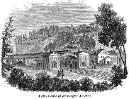
The 24th of June was a fresh, bracing day, when we assembled
at half-past six in the morning at the spacious depot, which is
near completion, and were speedily off over the lowlands to the
Relay House, where we breakfasted on the Maryland luxuries of
"soft-crabs" and "spring-chickens"—two
delicacies which the unenlightened may get an idea of if they
can imagine the luscious flavor of solidified cream browned over
a hickory fire in clover-scented butter.
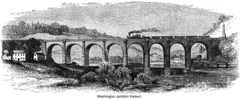
The Relay House is the first spot where one observes the broken
country through which so much of this road lies, for it is situated
on the rise of the hills, near the place known as Elk Ridge Landing,
to which vessels of considerable tonnage came, in 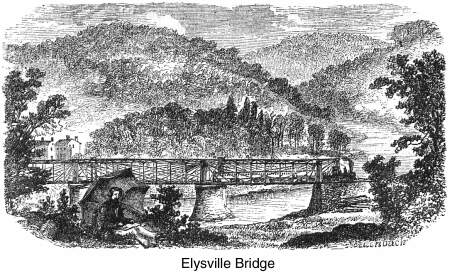 the early days of Maryland, to load with
tobacco for European markets. In consequence of diminished water,
it has lost its ancient bustle and importance as a port of entry,
and the Patapsco breaks through its picturesque gorge, with greatly
shrunken volume, to find its way to the Chesapeake. Here the railway
branches to the West and to Washington; the latter track crossing
the ravine on a tall viaduct of granite, and .the former pursuing
a beautiful and broken ledge of the stream toward its head-waters
in the hills. The imposing structure which spans the river with
eight arches of sixty feet chord, at a height of sixty feet above
the Patapsco, was one of the early designs of that distinguished
engineer Benjamin H. Latrobe, under whose direction the road has
been completed across the Alleghanies to the Ohio. In order to
obtain a better view of this massive structure, which harmonizes
so completely in color and dimensions with the scenery, we descended
to the water's edge, where, framed like a picture in the granite
arches, the valley opened westward, with its sloping hills, villa-studded
groves, and placid river, and the Avalon Works relieved against
the sky in the remote gap.
the early days of Maryland, to load with
tobacco for European markets. In consequence of diminished water,
it has lost its ancient bustle and importance as a port of entry,
and the Patapsco breaks through its picturesque gorge, with greatly
shrunken volume, to find its way to the Chesapeake. Here the railway
branches to the West and to Washington; the latter track crossing
the ravine on a tall viaduct of granite, and .the former pursuing
a beautiful and broken ledge of the stream toward its head-waters
in the hills. The imposing structure which spans the river with
eight arches of sixty feet chord, at a height of sixty feet above
the Patapsco, was one of the early designs of that distinguished
engineer Benjamin H. Latrobe, under whose direction the road has
been completed across the Alleghanies to the Ohio. In order to
obtain a better view of this massive structure, which harmonizes
so completely in color and dimensions with the scenery, we descended
to the water's edge, where, framed like a picture in the granite
arches, the valley opened westward, with its sloping hills, villa-studded
groves, and placid river, and the Avalon Works relieved against
the sky in the remote gap.
 The road turns
around a bluff on quitting the Relay House for the West. It leaves
the viaduct on the left, passes the Avalon Iron Works, and skirting
the river for six miles, reaches the village of Ellicott's Mills.
Throughout this transit there is charming variety of hill, rock,
and river scenery, interspersed with continual evidences of agricultural
and manufacturing industry, the whole overshadowed at this season
by fresh foliage among the granite which abounds in this district.
From the Relay House to Ellicott's Mills, and thence onward to
Elysville, the Patapsco gradually narrows and brawls over a rocky
bed, affording valuable water-power which has been prosperously
employed. We halted at Elysville for a short time to examine the
peculiarities of an iron bridge invented by Mr. Wendel Bollman,
of Baltimore, spanning the Patapsco with a double track of three
hundred and forty feet. There are so many valuable elements of
strength, security, and permanence in this invention, that I would
be glad to describe it minutely; but towers, chords, cores, tenons,
rivets, sockets, suspension rods, and their scientific combinations,
afford but dull entertainment for general readers, and, accordingly,
I must refer the more curious to the ingenious artist himself,
whenever they desire to promote the safety of railways by counteracting
the evil effects of expansion and contraction, which have been
so disastrous to many of the iron bridges of our country.
The road turns
around a bluff on quitting the Relay House for the West. It leaves
the viaduct on the left, passes the Avalon Iron Works, and skirting
the river for six miles, reaches the village of Ellicott's Mills.
Throughout this transit there is charming variety of hill, rock,
and river scenery, interspersed with continual evidences of agricultural
and manufacturing industry, the whole overshadowed at this season
by fresh foliage among the granite which abounds in this district.
From the Relay House to Ellicott's Mills, and thence onward to
Elysville, the Patapsco gradually narrows and brawls over a rocky
bed, affording valuable water-power which has been prosperously
employed. We halted at Elysville for a short time to examine the
peculiarities of an iron bridge invented by Mr. Wendel Bollman,
of Baltimore, spanning the Patapsco with a double track of three
hundred and forty feet. There are so many valuable elements of
strength, security, and permanence in this invention, that I would
be glad to describe it minutely; but towers, chords, cores, tenons,
rivets, sockets, suspension rods, and their scientific combinations,
afford but dull entertainment for general readers, and, accordingly,
I must refer the more curious to the ingenious artist himself,
whenever they desire to promote the safety of railways by counteracting
the evil effects of expansion and contraction, which have been
so disastrous to many of the iron bridges of our country.
We wound westwardly from Elysville five miles till we struck
the fork of the Patapsco, when we turned its western branch, passed
the Mariottsville quarries, crossed the river on an iron bridge
of fifty feet, ran through a tunnel four hundred feet long, and
hurrying across meadowlands, followed a crooked gorge to Sykesville
in the heart of a region abounding in minerals. For a considerable
distance beyond this settlement we traversed a rough, level country—our
road, for the most part, cut from the solid rock—till, leaving
the region of granite, it shortly struck Parr's Ridge, which divides
the Valley of the Patapsco from that of the Monocacy and Potomac.
From the top of this elevated grade there are superb views of
the Plains of Frederick, backed by spurs of the Blue Ridge, which
stand out like advanced sentinels in the midst of luxuriant farm-land.
On its western side the quiet Monocacy waters a rural district
till it issues by a gorge, and coasts the eastern slopes to the
termination of the mountains. Near the mouth of this placid stream,
the insulated masses of Sugar-loaf Mountain shoot up abruptly;
while, on the other side, the slopes, spurs, and transverse valleys
are dark with magnificent groves of choicest timber.
With such scenery on all sides, we passed the Monocacy, and,
quitting its valley, crossed, southwestwardly, over limestone
levels, between the Catoctin and Sugar Loaf, and struck the Potomac
at no great distance from the Point of Rocks, where the railway
runs on a ledge cut from the precipice of the Catoctin Mountain,
towering up on the right, and supported by broad embanking walls
that separate it from the canal and river on its left.
The Potomac, at this point, is a third of a mile wide, and
foams over a bed of ledges crossing it at right angles like so
many fractured barriers, denoting the conflict between the ridge
and river when it burst through the hills, Such, with few intermissions,
is the character of scenery from the Point of Rocks to Harper's
Ferry, which is built on a narrow, declivitous tongue, lying 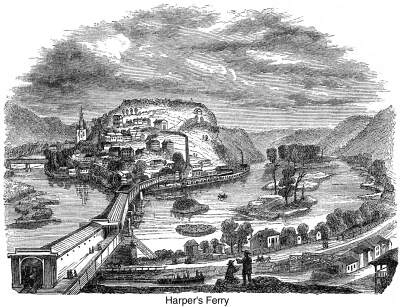 directly in the confluence
of the Shenandoah and Potomac, and washed on either side by those
noble streams. The railway reaches it by a stupendous curving
bridge of nine hundred feet over the latter; and as the mountain
steeps converge precipitously at all points about the gap, but
small space is left for building with accessible convenience.
Nearly all the level river-margin has been used for the National
Armory, so that the town scrambles picturesquely among the upland
bluffs, till the hill-top, like the end of all things, is terminated
by the groves and monuments of a cemetery.
directly in the confluence
of the Shenandoah and Potomac, and washed on either side by those
noble streams. The railway reaches it by a stupendous curving
bridge of nine hundred feet over the latter; and as the mountain
steeps converge precipitously at all points about the gap, but
small space is left for building with accessible convenience.
Nearly all the level river-margin has been used for the National
Armory, so that the town scrambles picturesquely among the upland
bluffs, till the hill-top, like the end of all things, is terminated
by the groves and monuments of a cemetery.
Our first visit was to the Armory, where we were introduced
to all the mysteries in this wonderful assemblage of contrivances
for death. Every thing was exhibited and set in motion—from
the ponderous tilt-hammers, which weld steel into solidity, down
to the delicate operations by which the impulse of a hair can
put these terrible engines in action. I was soon struck by the
fact that, after all, it is not so easy to kill a man—especially,
if we consider the intricate preparations which have to be made
in constructing weapons for human slaughter. We learned that a
musket consists of forty-nine pieces, and that the number of operations
in completing one—each of which is separately catalogued
and valued—amount to three hundred and forty-six; all, in
some degree, requiring different trades and various capacities
for execution; so that, perhaps, no man, or no two men in the
establishment, could perform the whole of them in manufacturing
a perfect weapon!
I confess that, with but little turn for mechanical science,
most of these complicated machines were rather surprising than
comprehensible to me; so that, while my companions strolled through
the apartments in quest of instruction, I followed leisurely in
their rear, rather grieving than glorying in the inventive skill
that had been lavished on their construction under national auspices.
It may be considered more sentimental than practical in the present
belligerent state of mankind, to doubt the wisdom of making military
preparations under the amiable name of "defense" yet I have never been able to understand why it should not
be "constitutional" to create as well as to kill, and
to make a sickle as well as a sword! Why is it that political
law allows millions for the belongings of war, and denies a dollar
to those genial arts which, in ten years, would do more for the
progress of 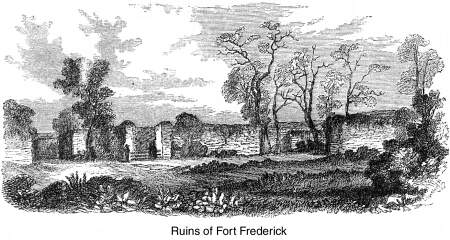 humanity
than centuries of traditionary force have effected for its demoralization?
Nay, how much more beneficially would these hundreds of workmen
be employed, if government devoted their labor to the manufacture
of such unpicturesque instruments as hoes, spades, rakes, axes,
pitchforks, plows, and reaping machines; and if the army, which
is to wield the perilous weapons that axe strewn in every direction,
were transmuted, under national patronage, into cultivators of
those "homesteads" which politicians so cheaply vote
them! But, alas! the soldier is epic, and the farmer only pastoral,
and pageantry beats homeliness all the world over!
humanity
than centuries of traditionary force have effected for its demoralization?
Nay, how much more beneficially would these hundreds of workmen
be employed, if government devoted their labor to the manufacture
of such unpicturesque instruments as hoes, spades, rakes, axes,
pitchforks, plows, and reaping machines; and if the army, which
is to wield the perilous weapons that axe strewn in every direction,
were transmuted, under national patronage, into cultivators of
those "homesteads" which politicians so cheaply vote
them! But, alas! the soldier is epic, and the farmer only pastoral,
and pageantry beats homeliness all the world over!
These lackadaisical fancies floated through my mind as I walked
over the half mile of armory; and I hope I may not be set down
as "too progressive" or "Utopian," if I divulge
them in this public confessional.
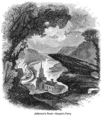
It was noon when we left the Armory and climbed to the fragment
of Jefferson's Rock, which affords the best coup d'oeil of this celebrated scenery. It was a fatiguing tramp under
a mid-day sun, but we found a breeze singing down the gorge of
the Shenandoah when we rested under the old pine-tree among the
cliffs. The rock itself is of very little interest, except for
its association with Mr. Jefferson's name, and its remarkable
poise on a massive base. The drawing at the beginning of this
article presents an accurate view of the whole scene. From the
gap between the fragments the prospect combines the grand and
beautiful in a wonderful degree. Beyond the brow of the hill very
little of the town is seen to disfigure the original features
of the prospect, so that the wilderness of mountain, forest, and
water may still be as freshly enjoyed as they were by the earliest
travelers. Indeed it is impossible for language to sketch the
spirit of the spot more vividly than is done in the bold penciling
of Jefferson. "You stand,'' says he, "on a very high
point of land; on your right comes up the Shenandoah, having ranged
the foot of the mountain a hundred miles to seek a vent; on your
left approaches the Potomac in quest of a passage also. In the
moment of their junction they rush together against the mountain,
rend it asunder, and pass off to the sea." In a few distinct
words of outline we have the geology and geography of the spot
before us; but when the sun is lower and the shadows broader than
at the time of our visit, so as to impart variety of tone and
effect to the scene, it is difficult to conceive a wilder prospect
than the mountains forming the gap, or a more placid landscape
than that which waves away beyond it, till hill, forest, and river
fade in the east. There is a remarkable contrast between the roughness
of the foreground and the pastoral quiet of the distance, so that
the very landscape seems to teach the need and harmony of repose
after struggle.
We dined in the cars as they rolled along slowly to Martinsburg,
where we tarried for the night after a stroll through the ancient,
hospitable town, examining the extensive work-shops and establishments
connected with the railway. Martinsburg is the centre of a rich
country in the hands of generous proprietors, and the converging
point of considerable trade between the mountain foot and sea-board.
We were up betimes on the morning of the 25th; for our hotel
was near the track, and the incessant passage of trains during
the night was not the most exquisite anodyne for tired travelers.
I do not remember any striking scenery till we crossed Back Creek
on a stone viaduct with a single arch of eighty feet, and once
more opened the Potomac Valley with views of the North Mountain
and Sideling Hill in the distance. Beyond this point we stopped
to visit the remains of Fort Frederick, erected by the Colonial
government of Maryland in 1775. The ruins lie north of the river
beyond the canal; so that it was necessary to descend the steep
sides of the mountain glen, still covered with the original forest,
and cross a lake-like reach of the Potomac in batteaux to
the opposite shore, where we found the military wreck on the upper
levels of the river bank, about a quarter of a mile from its embowered
margin. The fort stands in the midst of cultivated fields, while
a wholesome-looking barn nestles under its dismantled walls. The
fortification is a square, with salient angles or bastions at
the four corners, and rises to the height of about fifteen feet.
There are no embrasures for cannon, nor is the structure massive
enough to resist artillery; but as it was built for frontier defense,
it was probably rather a garrison for riflemen than a regular
fortress capable of sustaining an attack of disciplined troops.
The four substantial walls have been little harmed in the lapse
of a hundred years. Their interior is overgrown 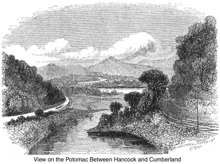 with weeds and bushes; the magazine is
a heap of stones; the barracks have disappeared altogether; the
gates are gone; large trees flourish in the corner bastions; ivy
grows over portions of the wall; but, with all these evidences
of decay, we were glad to hear that the farmer on whose land it
stands does not allow a stone to be removed, and is determined
to preserve it as a historical relic of our Maryland forefathers.
The only inhabitant we found in the abandoned fort was a black
snake of considerable size; but as he was speedily slain by some
of our followers, I suppose the last emblem of hostility has been
destroyed within the walls, and the gray ruin left to the innumerable
thrushes that were singing in its solitude.
with weeds and bushes; the magazine is
a heap of stones; the barracks have disappeared altogether; the
gates are gone; large trees flourish in the corner bastions; ivy
grows over portions of the wall; but, with all these evidences
of decay, we were glad to hear that the farmer on whose land it
stands does not allow a stone to be removed, and is determined
to preserve it as a historical relic of our Maryland forefathers.
The only inhabitant we found in the abandoned fort was a black
snake of considerable size; but as he was speedily slain by some
of our followers, I suppose the last emblem of hostility has been
destroyed within the walls, and the gray ruin left to the innumerable
thrushes that were singing in its solitude.
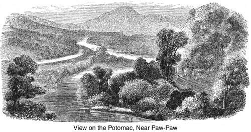
Beyond Fort Frederick, we began to touch the region of St.
Clair, Braddock, and Washington. West of Hancock, we halted at
Sir John's "Run," whence a short, brisk drive deposits
travelers at Berkeley Springs, whose virtues were recognized at
an early day by Washington and the Fairfaxes, and continue to
be acknowledged every summer by crowds from Maryland and Virginia.
The Valley of the Potomac has nearly the same characteristics
through its whole length, from this place to Cumberland. The road
winds along the stream, and about the base of mountain spurs—some
rising suddenly in distinct cones, and others broken into steep
cliffs, displaying their strata-like layers of masonry. Sideling
Hill, Tower Hill, and Green Ridge are consecutively passed, till,
in the neighborhood of Warrior Mountain, we pass into beautiful
meadow-lands which are of historic interest on the line of travel
between the sources of the Patapsco and the head-waters of the
Ohio.
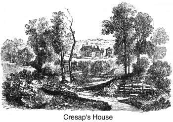
It was to this charming valley, sheltered by the first spurs
of the Alleghanies, that the celebrated Colonel Thomas Cresap
removed, about 1742, from the neighborhood of the Susquehanna,
and established himself in the homestead which our artist has
sketched, and which is still owned and occupied by his descendants.
 Some five
years afterward, when Washington was in his seventeenth year,
Lord Fairfax dispatched the enterprising youth on his "surveying
expedition" to this region; and, among his early experiences
in woodcraft he records that, "after vainly watching for
the river to subside from an unusual freshet, he crossed the Potomac
in a canoe, from the neighborhood of Bath, and reached the Colonel's
house, opposite the South Branch, by a weary ride of forty miles,
in continual rain, over the worst road ever trod by man or beast."
Here he tarried several days for fair weather, and was entertained
by the savage sports of an Indian war-party, whose wild propensities
were probably subdued by the judicious application of a little
grog!
Some five
years afterward, when Washington was in his seventeenth year,
Lord Fairfax dispatched the enterprising youth on his "surveying
expedition" to this region; and, among his early experiences
in woodcraft he records that, "after vainly watching for
the river to subside from an unusual freshet, he crossed the Potomac
in a canoe, from the neighborhood of Bath, and reached the Colonel's
house, opposite the South Branch, by a weary ride of forty miles,
in continual rain, over the worst road ever trod by man or beast."
Here he tarried several days for fair weather, and was entertained
by the savage sports of an Indian war-party, whose wild propensities
were probably subdued by the judicious application of a little
grog!
Washington's family had known Cresap when he lived in Eastern
Maryland, and the stout pioneer was soon employed in his new quarters
by the principal persons interested in the Ohio Land Company,
which had received a grant of 500,000 acres beyond the Alleghanies,
between the Monongahela and Kanawha. The object of this enterprise
was to settle land and develop the West. The French, who regarded
the Valley of the Mississippi as their own, became alarmed at
this inroad on their asserted borders, and extended a line of
military posts throughout the West, embracing a vast extent of
territory claimed by Great Britain. In spite of all opposition,
the British grantees pursued their enterprise zealously, from
what was then the heart of our Eastern settlements, and Cresap's
knowledge of the country and frontier-life was of immense service
in tracing and keeping open the first path over the Alleghanies
to Red Stone Old Fort—the modern Brownsville. As one of the
company's agents, he employed Nemacolin, a friendly Indian, to
mark and clear a way along the trail of the tribes, and he performed
his duty so well that Braddock pursued the route when he marched
to dislodge the French from Fort Duquesne.
 But those were
days in which no questions were asked, in such lonely outposts,
save at the rifle's mouth; and, of course, Cresap and his family
often became engaged in struggles with the savages, who were roused
by the French. The mountains and neighboring lowland swarmed with
these guerrilleros, and the pioneer took the "war-path,"
in Indian fashion, with his children and retainers, striking the
foe at the western foot of Savage Mountain, where his son Thomas
fell; and at Negro Mountain, farther west, where a gigantic African,
who belonged to the party, bequeathed his name, in death, to the
towering cliffs. Dan's Mountain, in the neighborhood of Savage,
received its title from some hardy exploits of his son Daniel;
and it was amidst scenes of danger like these that Captain Michael
Cresap—so unjustly charged with the murder of Logan's family—was
brought up, and obtained his early lessons in Indian warfare.
But those were
days in which no questions were asked, in such lonely outposts,
save at the rifle's mouth; and, of course, Cresap and his family
often became engaged in struggles with the savages, who were roused
by the French. The mountains and neighboring lowland swarmed with
these guerrilleros, and the pioneer took the "war-path,"
in Indian fashion, with his children and retainers, striking the
foe at the western foot of Savage Mountain, where his son Thomas
fell; and at Negro Mountain, farther west, where a gigantic African,
who belonged to the party, bequeathed his name, in death, to the
towering cliffs. Dan's Mountain, in the neighborhood of Savage,
received its title from some hardy exploits of his son Daniel;
and it was amidst scenes of danger like these that Captain Michael
Cresap—so unjustly charged with the murder of Logan's family—was
brought up, and obtained his early lessons in Indian warfare.
We reached Cumberland, in a brisk shower, about four o'clock;
but were soon relieved from anxiety as to accommodations by our
generous friends in this charming city. We should do violence
to their feelings if we spoke publicly of what is habitual with
them and characteristic of the country; but we should equally
violate ours if we avoided the expression of gratitude for a pleasant
season in Cumberland, spent in the midst of unostentatious people
and "old Maryland hospitality."
Soon after
sunrise on the 26th, we joined a special train, belonging to the
Eckhart Mining Company, to visit the coal region for which Maryland
is becoming celebrated all the world over.
In days of old, the mountains which rise abruptly in the west,
1800 or 2000 feet above the level of Cumberland, probably extended
northwestwardly in an unbroken wall, till some of those great
convulsions which formed the water gaps of the Delaware and Potomac
let loose the pent-up floods on their way to the sea. It was through
one of these gigantic chasms in the chain that we penetrated the
Alleghanies toward the coal region. The "Narrows of Wills's
Mountain," is the outlet of Braddock's, Wills's, and Jennings's
Runs, which nearly converge at this point on the western slope,
and, by their united force in the early day, burst open this splendid
gap, which extends for more than a mile, five hundred feet wide,
with precipitous walls of near nine hundred!
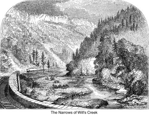 The strata throughout
this chasm were laid bare by the original fracture. In portions
the lines of grayish sandstone are nearly vertical, as if mashed
against the flank of the mountain. A scant vegetation of creepers
and bushes has sprung up in the clefts, and in many places broken
rocks, tumbled confusedly from the mountain-top, have filled the
edges of the gorge with heaps of Cyclopean fragments.
The strata throughout
this chasm were laid bare by the original fracture. In portions
the lines of grayish sandstone are nearly vertical, as if mashed
against the flank of the mountain. A scant vegetation of creepers
and bushes has sprung up in the clefts, and in many places broken
rocks, tumbled confusedly from the mountain-top, have filled the
edges of the gorge with heaps of Cyclopean fragments.
Passing through this wilderness of romantic disorder, we seem
to enter the very core of the mountains, piled up on all sides
in wooded slopes and narrow valleys. Directly in front is Dan's
Mountain, while west of it rise the higher and darker summits
of the Savage. Between these two mountains, extending in length
twenty miles in Maryland, with an average breadth of four, is
the site of the celebrated coal basin, traversed by a ridge or
upland glade, dividing it into two unequal parts. This valuable
mineral field is fifteen hundred feet above tidewater, and nearly
a thousand above Cumberland. It is not horizontal in its strata,
but gets its name of "basin" from the trough-like curvature
of the veins, whose formation may be comprehended by imagining
the process of their original disturbance by volcanic action.
Those rock-herbariums, the fossils, demonstrate that coal is
the result of buried vegetation. It is presumed that the great
Alleghanian field was the bed of an ancient lake, which has been
drained by the Mississippi, Susquehanna, St. Lawrence, and Hudson,
as the head waters of the Alleghany, Genesee, Susquehanna, Chesapeake,
and St. Lawrence, take their rise within an area of five miles.
If we imagine the original bed of this basin to have been formed
by separate deposits of coal, iron, limestone, and other materials,
lying horizontally on each other, and the tops of the present
mountains to have been nearly on a line with these levels, we
shall obtain an accurate idea of the mode in which the strata
were bent into curves by the upheaval of Dan's Mountain on the
cast, and Savage Mountain on the west, bearing with them as they
rose the skirts of the strata, while they left their centres undisturbed.
 The most reliable
information as to the quantity of this mineral, diffuses it over
an area of about a hundred and fifty square miles; and in the
best mines, it is calculated that from eleven thousand to thirteen
thousand tons may be produced from every, acre.
The most reliable
information as to the quantity of this mineral, diffuses it over
an area of about a hundred and fifty square miles; and in the
best mines, it is calculated that from eleven thousand to thirteen
thousand tons may be produced from every, acre.
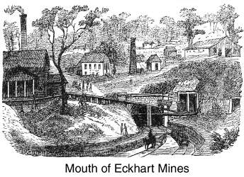
Our ascent to the Eckhart mines by rail and locomotive was
my first adventure of the character, and I must confess, that
although we rose many hundred feet in the space of eight or nine
miles, I experienced none of those startling sensations which,
in recent accounts of mountain roads, have made our heads dizzy
with imaginary terror. The company which we visited on this occasion
appears to be one of the most prosperous in the district, owning
a railway, several villages, ten thousand acres of coal land,
immense quantities of timber and farming country, and employing
about six hundred workmen.
I had so often visited the interior of mines that I did not
accompany my friends when, furnished with candles and forming
a sort of dismal procession, they entered the mouth of the mine
and twinkled away in its dark perspective like so many expiring
sparks. I sat down on the hill above the entrance, and, for an
hour or more, enjoyed the air of the hills and the superb panorama
of mountain, valley, and forest, with its broad masses of light,
shadow, verdure, and blue overlapping distance. The prospect is
not bounded by an extremely remote horizon, as is the case from
some higher points, but there is still sufficient elevation and
extent to afford most of the fine mountain effects that are to
be found throughout the Alleghanies.
After the return of our companions (who came forth from the
bowels of the earth limp and hungry, but extremely learned on
the mysteries of mining), and a hearty refection at the hospitable
board of Mr. Henderson, carriages and horses were put in requisition
to pass the central ridge which binds Dan's Mountain to Savage
Mountain. A pleasant drive of an hour over the 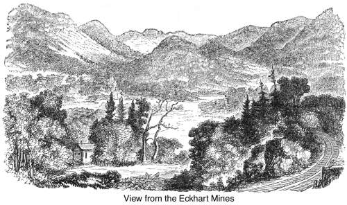 breezy upland, through the forest, took
us to a vestige of Braddock's Road, which the patriotic owner
has fenced in, for fifteen or twenty yards, as a post-and-rail
monument to the defeated General? The army's route may still be
traced through the woods over the mountains; and on its course,
at no great distance from the inclosure, there is still an ancient
stone which indicates the number of miles to Red Stone Old Fort,
and terminates with the valorous legend of—
breezy upland, through the forest, took
us to a vestige of Braddock's Road, which the patriotic owner
has fenced in, for fifteen or twenty yards, as a post-and-rail
monument to the defeated General? The army's route may still be
traced through the woods over the mountains; and on its course,
at no great distance from the inclosure, there is still an ancient
stone which indicates the number of miles to Red Stone Old Fort,
and terminates with the valorous legend of—
"Our country's rights we will defend!"
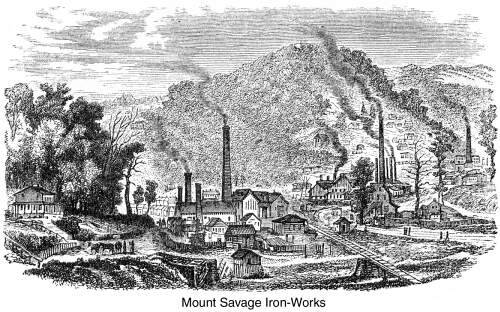
We passed rapidly through Frostburg, a fresh mountain village,
flourishing under the impetus of an increasing neighborhood; and
striking off to the left, wound slowly down for several miles
of forest glen, along the margin of Jennings's Run, to the works,
where the Mount Savage Company is engaged in the manufacture of
iron.
Its proprietors own five thousand acres of timber and mineral
land; three blast furnaces, capable of producing four hundred
tons of pig iron per week; several forges; rolling mills, equal
to the furnishing ten thousand tons of rail per annum; a foundery;
machine shops; a fire-brick factory, yielding thirteen hundred
thousand a year; and three hundred dwellings for the uses of the
establishment, which, when in full blast, gives employment to
nearly a thousand people. Besides these large elements of wealth,
the Company owns the Cumberland and Pennsylvania Railroad (worked
under a distinct charter), connecting its village with Frostburg,
and descending to Cumberland by a grade of eleven hundred feet.
We found these works under the personal superintendence of the
president, Mr. John A. Graham; and the. road under the care of
Mr. Slack, to whom we were indebted for marked attention during
our brief visit to the country.
It was a scorching day in the narrow valley through which the
sun poured down with all its natural and reflected heat; but we
penetrated the sweltering furnace and rolling mill, where we saw
all the ponderous operations by which the blazing metal is rolled
into bars to bear the freight and travel of our country.
 In the midst
of all these industrial pursuits, the quiet mountain-sides have
been dotted, in romantic situations, with the seats of enterprising
persons who set all this enginery in motion; and a visitor is
transported from the rough scenes I have mentioned to elegant
residences, filled with every attraction that refinement and hospitality
can require. Cultivated society is wreathing the tops of these
wild old mountains with a garland of delicious homes, and I can
hardly doubt that in a few years the allurements of sport and
scenery, as well as the lucrative pursuits of trade, will make
these noble uplands the abode of thousands.
In the midst
of all these industrial pursuits, the quiet mountain-sides have
been dotted, in romantic situations, with the seats of enterprising
persons who set all this enginery in motion; and a visitor is
transported from the rough scenes I have mentioned to elegant
residences, filled with every attraction that refinement and hospitality
can require. Cultivated society is wreathing the tops of these
wild old mountains with a garland of delicious homes, and I can
hardly doubt that in a few years the allurements of sport and
scenery, as well as the lucrative pursuits of trade, will make
these noble uplands the abode of thousands.
We left our carriage at Mount Savage, and returned by the company's
railway along a more southerly route than the one we pursued on
our way to the Eckhart Mines. The scenery throughout was strikingly
picturesque; there were some distant glimpses of mountain and
valley; but the road was mostly confined to narrow dells, whose
precipitous sides were of the same broken wall-like character
as the masses through which we entered the mountains in the chasm
of Wills's Creek.*
* We had time to visit only one coal-mine, and the iron-works.
There are many other companies in this region, among which I recollect
the New York Mining Company; the Maryland, the Alleghany, the
Borden, the Wither's, the Astor, the Cumberland Coal and Iron
Company, the Washington Coal Company, the Frostburg Coal Company,
the New Creek Company; the American, the Swanton, the Hampshire,
the George's Creek Coal and Iron Company, etc., etc., etc.
I know few inland towns more charmingly situated than Cumberland,
on the slope of a superb amphitheatre, with its background of
mountains, approached through vistas of forest-covered spurs.
From the earliest times its geographical position at the foot
of the Alleghanies, as the central point between the navigable
waters of the east and west, made it attractive to our military
and commercial people.
Old Fort Cumberland was built there because it was the frontier
outpost on the Indian trail; Braddock made it the rendezvous of
his luckless enterprise for the same reason; our forefathers established
it as the entrepot for trade with the hunters, trappers, and settlers
of the West; by general consent it became the route of the National
Road; and, ever since the days of the Revolution, there is hardly
a traveler from the sea-board to the West who has not breakfasted,
dined, supped, or changed horses at Cumberland.
Most of the old historic traces have been obliterated by the
growth of the town since the opening of the adjacent mines and
the completion of canal and railway. We visited the site of Old
Fort Cumberland on the afternoon of our arrival. The rounded knob
of a hillock rises from the stream which winds about its base
with a short curve, so as to afford hardly more room than is 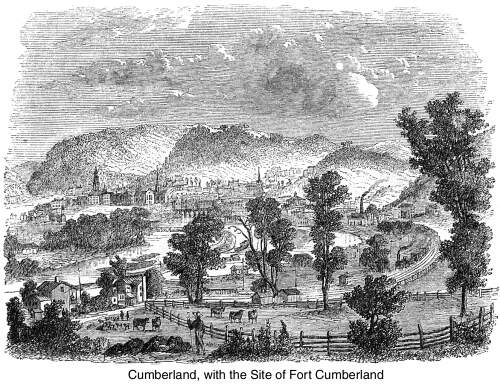 necessary for a broad
walk around the Gothic Church, which occupies the site of the
fort, and "whose canons" as a joker said, "have
displaced the cannons of the fort." A depression in
the ground marks the old well as the sole survivor of the military
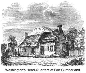
past. Until 1846 or 1847, the weather-beaten hovel which Washington
occupied as his quarters more than a hundred years ago, still
stood behind the fort in the rickety rain delineated by our artist;
but it has been removed to make way for a modern dwelling.
necessary for a broad
walk around the Gothic Church, which occupies the site of the
fort, and "whose canons" as a joker said, "have
displaced the cannons of the fort." A depression in
the ground marks the old well as the sole survivor of the military
past. Until 1846 or 1847, the weather-beaten hovel which Washington
occupied as his quarters more than a hundred years ago, still
stood behind the fort in the rickety rain delineated by our artist;
but it has been removed to make way for a modern dwelling.
On Green Street there are two houses—said to have been
built by Braddock—constructed of stout timber, heavily ironed
and riveted on both sides. One, from the manner in which its doors
are made, is supposed to have been a jail; the other a two-story
log and weather-boarded edifice—still goes by the name of
Braddock's Court. Washington was here in 1753, '54, '56; and by
a journey of forty or fifty miles over the National Turnpike,
the earliest scenes of his military life may be visited in the
neighborhood of the Great Meadows, where Braddock died and was
buried in the forest.
It was in that quarter that Washington endured the stern trials
of Fort Necessity (whose outlines may still be traced in the field),
and had his first fight, at the surprise and capture of
Jumonville's party. It was here, too, at the age of twenty-two,
that he declared there was "something charming in
the sound of whistling bullets!" a youthful vaunt for which
Walpole rated him as "a brave braggart;" George the
Second thought "he would have expressed himself differently
if he knew more about them;" and which he himself, in after
years, denounced as the ejaculation of a "very young
man!"
 There is another
great artery for trade and travel across this mountain region,
about to be completed, from Cumberland to Pittsburg, through the
heart of the Alleghanies at Connelsville. Our limited time, however,
did not allow us to explore the route in its present rough state—an
expedition we should have been exceedingly glad to make, as it
would have prepared us to appreciate the difficulties already conquered by the same engineer on the road to Wheeling.
There is another
great artery for trade and travel across this mountain region,
about to be completed, from Cumberland to Pittsburg, through the
heart of the Alleghanies at Connelsville. Our limited time, however,
did not allow us to explore the route in its present rough state—an
expedition we should have been exceedingly glad to make, as it
would have prepared us to appreciate the difficulties already conquered by the same engineer on the road to Wheeling.
We left Cumberland by a stone viaduct of fourteen arches, fifty
feet span each, which Mr. Latrobe designed and built over Wills's
Creek, at an elevation of thirty-five feet above the bed of the
stream. As a type of the structures of all classes and for all
purposes along this route—whether machine-shops, engine-houses,
depots, water tanks, or stations—this bridge may be taken
as a striking specimen. In massive solidity it resembles those
noble works of the Empire, whose remains, after the lapse of two
thousand years, still excite our wonder on the Campagna of Rome.
For twenty-two miles we skimmed over a gradually ascending
level, toward the southwest, along the north branch of the Potomac,
which runs between the western slope of Knobly, and the eastern
feet of Dan's and Wills's mountains. The Knobly range, rising
in detached bosses, often slopes gracefully into the rich sward
of the valley, while the stream is fringed by trees and herbage,
till the main Cordillera of the Alleghanies is approached,
and the defiles begin to rise with irregular, abrupt edges, curbing
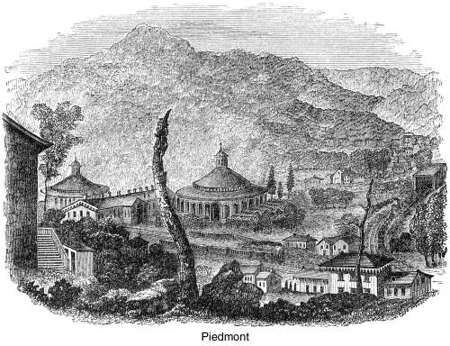
the waters into a gorge. For the last six miles toward Piedmont,
the river lies in a chasm cut by its torrent-like course through
the mountain feet. About twenty-one miles from Cumberland we crossed
the Potomac on a bridge of timber and iron; and then, winding
by easy curves through romantic scenery, as if feeling our way
through approaching difficulties, we passed the 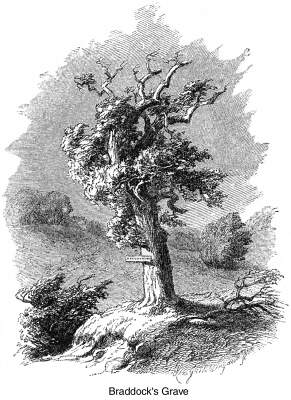 Queen's Cliff, Thunder Hill, and the
steep ledges of Dan's Mountain, and rested in the broad lap of
levels deposited by the mountain wash at Piedmont. This remote
village has sprung up in its solitude at the steep base of the
Alleghanies, as a sort of breathing-place, where the fiery horse
is to pause, gird up his loins, and renew his strength for a struggle
with the giants that stand before him in all their defiant grandeur.
Queen's Cliff, Thunder Hill, and the
steep ledges of Dan's Mountain, and rested in the broad lap of
levels deposited by the mountain wash at Piedmont. This remote
village has sprung up in its solitude at the steep base of the
Alleghanies, as a sort of breathing-place, where the fiery horse
is to pause, gird up his loins, and renew his strength for a struggle
with the giants that stand before him in all their defiant grandeur.
No one, I am sure, has ever looked westward from this spot
without wondering how the passage is to be effected; yet no one
has made the journey without equal surprise at the seeming ease
by which science and energy have overcome every impediment. As
you pass forward from Piedmont, the impression is that you are
about to run a tilt against the mountain flank with blind and
aimless impulse; but a graceful curve winds the train out of harm,
and you move securely into the primeval forest, feeling the engine
begin to tug up the steeps as it strikes the edge of Savage River,
which boils down the western shoulder of Savage Mountain. The
transit from the world to the wilderness is instantaneous. Mr.
Bancroft and I mounted the engine at this spot so as to enjoy
an unobstructed view of the scenery during the ascent; and although
a gust began to growl over the mountains, with frequent flashes
of lightning and thunder, we kept our post, finding the grandeur
of the prospect enhanced by the rush of the storm as we rose higher,
and higher on the mountain flank.
No one has observed fine scenery without acknowledging the
difficulty of its description; for its impression is purely emotional, and emotion is so evanescent that the effort to condense it
into language destroys the sentiment as breath destroys the prisms
of a snow-flake. We may give a catalogue of pines, precipices,
rocks, torrents, ledges, overarching trees, and all the elements
that make one "feel the sublimity of a stern solitude;"
but I have never been able to convey, by words, the exact impression
of such scenes, nor do I believe we can obtain what is somewhere
called "a realizing sense" in the descriptions of others.
In this respect, music and painting have more power than language;
music has the spirituality which painting lacks, and painting
the body in which music is deficient; but, as their effects can
never be completely united, we must despair of influencing the
mind at second hand from Nature.
 And so we rolled
resistlessly upward, for seventeen miles, along the broad ledges,
seeing the tree-tops sinking as we swooped into the air, which
freshened as we rose; seeing the vale grow less and less, and
the summits that were just now above us come closer and closer
till we touched their level; seeing the river whence we started
shrink to a film in its bed; and seeing the narrow, upward, imprisoning
glimpse widen into a downward, distant reach.
And so we rolled
resistlessly upward, for seventeen miles, along the broad ledges,
seeing the tree-tops sinking as we swooped into the air, which
freshened as we rose; seeing the vale grow less and less, and
the summits that were just now above us come closer and closer
till we touched their level; seeing the river whence we started
shrink to a film in its bed; and seeing the narrow, upward, imprisoning
glimpse widen into a downward, distant reach.
On we hurried without halting but once, till we turned from
the Savage Valley into the Crabtree Gorge, along the flank of
the great Alleghany Backbone; and a few miles above Frankville
(an eyrie among the summits, some 1800 feet above tide, and 1100
feet above Cumberland), cast our eyes back toward the northeast
for a rapid glimpse of one of the grandest views in the mountains.
The gloomy masses of Savage Mountain tower on the right, fold
upon fold, and the eastern slopes of Meadow Mountain, with its
spurs, on the left; while between them the Savage River winds
away for miles and miles in a silvery trail till it is lost in
the distance. Throughout the whole passage from Piedmont to Altamont
(2620 feet above tide and the greatest elevation along the route)
the road constantly and almost insensibly ascends, in every portion
filling the mind with a sense of as perfect security as if the
transit were made, in a coach.
At Altamont we dipped over the eastern edge of the Alleghanies,
and by a slight descent entered the highland basin of the old
mountain lakes, which extends over many thousands acres, and is
known as the "Glades." There the Youghiogheny takes
its rise, while the dividing ridge of the great Backbone sends
the water on one side into the Gulf of Mexico, and on the other
into 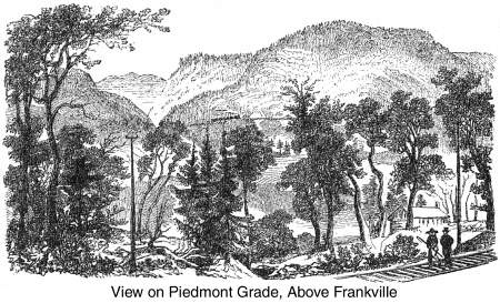 the Chesapeake.
These beautiful glades, or mountain meadows, are not connected
in a level field like our western prairies, but lie in broken
outlines, with small wooded ranges between them or jutting out
from their midst in moderate elevations. At this height the air
is extremely rarified and cool throughout summer; so that, although
the country is not adapted for agriculture, it is calculated for
every species of animal and vegetable life that is disposed to
run wild and take the world as it finds it. It is rich in all
the natural grasses that delight a herdsman, relieved by islands
of white-oak interspersed with alder; it is full of copious streams,
kept full and fresh by the clouds that condense round the summits;
its waters are alive with trout, and waste themselves in deep
cascades and falls after furnishing pools for the fish; it pastures
innumerable herds of sheep, whose tenderness and flavor rival
that of the deer which abound in the woods; wild turkeys and pheasants
hide among its oaks, beeches, walnuts, and magnolias; the sugar
maple supplies it with a tropical luxury in abundance; the woods
are vocal with larks, thrushes, and mocking-birds; and in the
flowering season nothing is gayer than the meadows with their
showy flowers.
the Chesapeake.
These beautiful glades, or mountain meadows, are not connected
in a level field like our western prairies, but lie in broken
outlines, with small wooded ranges between them or jutting out
from their midst in moderate elevations. At this height the air
is extremely rarified and cool throughout summer; so that, although
the country is not adapted for agriculture, it is calculated for
every species of animal and vegetable life that is disposed to
run wild and take the world as it finds it. It is rich in all
the natural grasses that delight a herdsman, relieved by islands
of white-oak interspersed with alder; it is full of copious streams,
kept full and fresh by the clouds that condense round the summits;
its waters are alive with trout, and waste themselves in deep
cascades and falls after furnishing pools for the fish; it pastures
innumerable herds of sheep, whose tenderness and flavor rival
that of the deer which abound in the woods; wild turkeys and pheasants
hide among its oaks, beeches, walnuts, and magnolias; the sugar
maple supplies it with a tropical luxury in abundance; the woods
are vocal with larks, thrushes, and mocking-birds; and in the
flowering season nothing is gayer than the meadows with their
showy flowers.
A little village is growing up at Oakland in the midst of these
glades, as a sort of nestling-place for folks who are willing
to be satisfied by being cool, quiet, and natural during summer.
We halted there for the night, and were not reluctant to ensconce
ourselves beneath blankets even in the "leafy month of June."
 In order to
make a new resort popular, it is necessary, as the world goes,
to have the lead of a fashionable belle or the command of a fashionable
doctor. Nature, of itself, is not sufficiently attractive for
artificial society; so that one must either be ill or be led, in order to adopt what is really good, and surround
it with allurements of French cookery, fast horses, a band of
music, and weekly balls. It was many years before Saratoga and
Newport ripened from a simple well and a wild sea-shore into the
luxuriant style of Bath and Brighton. Yet I do not despair of
seeing the day when the Maryland Glades, the head-waters of Potomac
and Cheat, and the romantic cascades of the neighboring Blackwater
will be crowded with health-hunters. The turn of Nature to be
in fashion again must come round; for when invention exhausts
the artificial (and the age of hoops seems verging on that desirable
end), there is no resource but simplicity. There are numbers of
reasonable people who must be eager to quit the beaten paths,
and escape to spots where they will not be stifled by society:
and these glades and mountain streams, with their constant coolness
and verdure, are precisely the places for them. For several years,
many of our Maryland and Virginian sportsmen have been fishing
the streams; beating up the deer, pheasants, and wild turkeys;
driving over the fine upland roads; drinking the pure water; exercising
robustly for a month or more; sleeping soundly every night of
July and August, and getting back to their work in the fall, as
hearty as the "bucks" they made war on in the mountains.
In order to
make a new resort popular, it is necessary, as the world goes,
to have the lead of a fashionable belle or the command of a fashionable
doctor. Nature, of itself, is not sufficiently attractive for
artificial society; so that one must either be ill or be led, in order to adopt what is really good, and surround
it with allurements of French cookery, fast horses, a band of
music, and weekly balls. It was many years before Saratoga and
Newport ripened from a simple well and a wild sea-shore into the
luxuriant style of Bath and Brighton. Yet I do not despair of
seeing the day when the Maryland Glades, the head-waters of Potomac
and Cheat, and the romantic cascades of the neighboring Blackwater
will be crowded with health-hunters. The turn of Nature to be
in fashion again must come round; for when invention exhausts
the artificial (and the age of hoops seems verging on that desirable
end), there is no resource but simplicity. There are numbers of
reasonable people who must be eager to quit the beaten paths,
and escape to spots where they will not be stifled by society:
and these glades and mountain streams, with their constant coolness
and verdure, are precisely the places for them. For several years,
many of our Maryland and Virginian sportsmen have been fishing
the streams; beating up the deer, pheasants, and wild turkeys;
driving over the fine upland roads; drinking the pure water; exercising
robustly for a month or more; sleeping soundly every night of
July and August, and getting back to their work in the fall, as
hearty as the "bucks" they made war on in the mountains.
Let me recommend Oakland to a cook who wishes to make a reputation
on venison and trout, and to a belle who is brave enough to
bring Nature into fashion!
 We slept at
Oakland. The mists hung low over these highlands long after sunrise,
and the air was so bracing that we found overcoats necessary as
we bowled across the great Youghiogheny, on a single arch of timber
and iron, and passed the picturesque Falls of Snowy Creek, where
the road quits the prairie and strikes a glen through which the
stream brawls in foam, contrasting bravely with the hemlocks and
laurels that line the pass.
We slept at
Oakland. The mists hung low over these highlands long after sunrise,
and the air was so bracing that we found overcoats necessary as
we bowled across the great Youghiogheny, on a single arch of timber
and iron, and passed the picturesque Falls of Snowy Creek, where
the road quits the prairie and strikes a glen through which the
stream brawls in foam, contrasting bravely with the hemlocks and
laurels that line the pass.
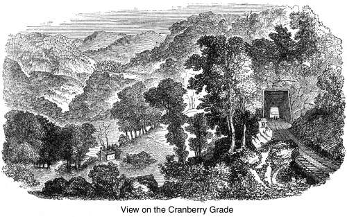
At Cranberry Summit the mountain-levels and glade-lands terminate,
at an elevation of 2550 feet above tide, and only 76 feet lower
than Altamont, where we entered the field, twenty miles back.
From this elevated point we catch the first grand glimpse of
the "Western World," in along gradual sweep down the
Alleghanies toward the affluents of the Ohio. The descent begins
instantly, along the slopes of Saltlick Creek, through a mass
of excavations, two tunnels, and fifty feet of viaduct. Downward
and downward we swept as comfortably as on a plain, till an easy
and almost imperceptible descent of twelve miles, through a forest
of firs and pines, brought us to the dark waters of Cheat River.
After the difficulties of ascending, crossing the Backbone of
the Alleghany, and descending its first western slope-all of which,
like Columbus's discovery, "seem so easy" now that they
are overcome—a new marvel has been accomplished in the preservation
of a high level by massive viaducts and by boring the mountains
with tunnels. On Cheat River, 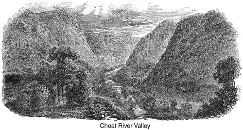 at the bottom of this descent, we approached the first
of these marvels, two noble arches of iron, firm and substantial
as the mountains they join. Then comes the ascent of Cheat River
Hill. Next are the slopes of Laurel and its spurs, with the river
on the right; till the dell of Kyer's Run is passed on an embankment,
and Buckeye Hollow crossed on a solid work whose foundations are
laid deeply below the level of the road. Both of these splendid
structures have walls of masonry, built of the adjacent rock.
at the bottom of this descent, we approached the first
of these marvels, two noble arches of iron, firm and substantial
as the mountains they join. Then comes the ascent of Cheat River
Hill. Next are the slopes of Laurel and its spurs, with the river
on the right; till the dell of Kyer's Run is passed on an embankment,
and Buckeye Hollow crossed on a solid work whose foundations are
laid deeply below the level of the road. Both of these splendid
structures have walls of masonry, built of the adjacent rock.
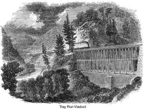
Beyond this we reach Tray Run, which is passed by an iron viaduct,
six hundred feet in length, founded on a massive base of masonry
as Arm as the mountain itself. All these remarkable works—chiefly
designed by Mr. Fink—have borne the trial of heat and frost,
travel and transportation, for several years; and when closely
inspected, their immense solidity, security, and strength, are
as easily tested by the eye as they have been by use and time.
 These beautiful
structures had hardly been passed when we wound upward across
Buckthorne Branch, and half a mile further, left the declivities
of Cheat River, with its brown waters dyed by the roots of laurel
and hemlock, and bordered by the bright flowers of the rhododendron.
Our last glimpse of this mountain river was through a tall arch
of forest, rounding off, far below, in its dark valley of uninhabited
wilderness.
These beautiful
structures had hardly been passed when we wound upward across
Buckthorne Branch, and half a mile further, left the declivities
of Cheat River, with its brown waters dyed by the roots of laurel
and hemlock, and bordered by the bright flowers of the rhododendron.
Our last glimpse of this mountain river was through a tall arch
of forest, rounding off, far below, in its dark valley of uninhabited
wilderness.
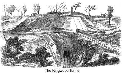
Beyond Cassidy's Ridge we encountered another, and perhaps
the most remarkable of these gigantic works. The road can only
escape from its mountain-prison by bursting the wall. Up hill
and down hill, through brake and ravine, it has cleft its way
from Piedmont, like a prisoner seeking release from his bars,
till at last it finds a bold barrier of 220 feet abruptly opposed
to its departure! For a while (before the entire completion of
the road) engineering skill led a track over this steep by
an ascent of 500 feet in a mile; but finally the giant has
been subdued, and the last great wall of the Alleghanies passed
by piercing the mountain. For nearly three years crowds of laborers
were engaged in blasting through solid rock the 4100 feet of the
Kingwood Tunnel, and a year and a half more was spent in shielding
it with iron and brick, so as to make its walls more solid, if
possible, than the original hills.
 For five miles
from the western end of this tunnel we descended to the broader
valleys about Raccoon Creek, and gliding through another tunnel
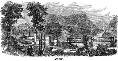
of 250 feet, followed the water till we entered the Tygart River
Valley, at Grafton, where the Northwestern Railway diverges to
Parkersburg, on the Ohio, ninety-five miles below Wheeling. The
establishments of the Company at this point are erected in the
most substantial way for the comfort and security of all who may
visit this interesting region.
For five miles
from the western end of this tunnel we descended to the broader
valleys about Raccoon Creek, and gliding through another tunnel
of 250 feet, followed the water till we entered the Tygart River
Valley, at Grafton, where the Northwestern Railway diverges to
Parkersburg, on the Ohio, ninety-five miles below Wheeling. The
establishments of the Company at this point are erected in the
most substantial way for the comfort and security of all who may
visit this interesting region.
There are few routes of travel in America—and none, probably,
by rail—worthier of attention than the region between the
slopes of the western glade-land to the mountain exit at Kingwood.
It is all absolute mountain, absolute forest, absolute solitude.
In winter it is the very soul of desolation, when the trees are
iced, like huge stalactites, from top to bottom, and the ravines
among the cliffs blocked with drifted snow. But in spring or summer
it presents splendid bits of forest scenery. The glens are narrow,
and there are few distant prospects; but there is every where
the same ragged gloom—the same overarching hemlocks and firs—the
same torrent roar, foaming over rocky beds—the same fringing
of thick-leaved laurel—the same oozy plashes of morass, rank
with dark vegetation—the same black mountain-face—the
same absence of people and farms—the same sense of absolute
solitude.
But in Tygart's Valley the landscape softens and becomes more
human, with the marks of agriculture and habitation, and the road
seems to bound along more gayly, as if exulting in its release
from the mountain. The river winds gently through rounder and
lower hills and broader meadows, broken only by "the Falls,"
which, in a few steep pitches, tumble seventy feet in the distance
of a mile. Not far from this point Tygart River and the West Fork
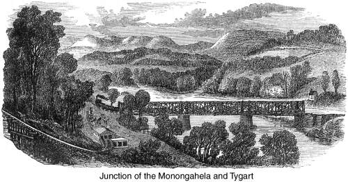
unite to form the Monongahela, which, a quarter of a mile below
the junction, is crossed by an iron viaduct 650 feet long—the
largest iron bridge, in America, and due to the engineering skill
of Mr. Fink.
 In these central
solitudes every thing seems to be the property of the wilderness—a
wilderness incapable of yielding to any mastery but that of an
engineer; and it may fairly become a matter of national pride
that scientific men were found in our country bold enough to venture
on grades by which any mountain may be passed. Where ground was
wanted, Nature seemed to have scooped it away; where it was not
wanted Nature seemed to have stacked it up for future purposes.
There are considerable difficulties between Baltimore and Cumberland;
yet, in a country which rises only 639 feet above tide in 179
miles, a road may be constructed by ordinary perseverance and
skill. But they who desire to understand the power of science
in conquering nature by steam and iron must climb and cross the
Alleghanies between Piedmont and Kingwood. The success of this,
the most difficult portion of the enterprise, is due to the engineering
of Mr. Latrobe and the financial energy of Mr. Swann.
In these central
solitudes every thing seems to be the property of the wilderness—a
wilderness incapable of yielding to any mastery but that of an
engineer; and it may fairly become a matter of national pride
that scientific men were found in our country bold enough to venture
on grades by which any mountain may be passed. Where ground was
wanted, Nature seemed to have scooped it away; where it was not
wanted Nature seemed to have stacked it up for future purposes.
There are considerable difficulties between Baltimore and Cumberland;
yet, in a country which rises only 639 feet above tide in 179
miles, a road may be constructed by ordinary perseverance and
skill. But they who desire to understand the power of science
in conquering nature by steam and iron must climb and cross the
Alleghanies between Piedmont and Kingwood. The success of this,
the most difficult portion of the enterprise, is due to the engineering
of Mr. Latrobe and the financial energy of Mr. Swann.
As the pioneer of such internal improvements in the Union,
it has been the school for subsequent railways, and deserves the
gratitude of scientific men for true principles of location and
construction. The bridging and tunneling alone, along the whole
route, amount to about five and a quarter miles; the laborers
and employees form almost five regiments in number; and, when
we take into consideration the depots, tanks, engines, rails,
station-houses, and innumerable cars for freight and travel, as
well as the two lines of telegraphic wires belonging exclusively
to the Company, which keep every portion in communication and
successful operation throughout the line, one no longer wonders
that twenty-five millions were, expended on the structure, but
is only surprised that the people of a small, single State could
accomplish so colossal an enterprise.
The remaining eighty or ninety miles between the junction of
the Tygart and Monongahela. rivers and the Ohio are full of rich
points of scenery, and contain some fine works. There are several
bridges of note, a tunnel of 2350 feet at Board-tree, and another
of 1250 feet in the ridge separating Fish Creek from Grave Creek.
The country is comparatively new, and the impetus given to
it by this improvement may be seen in the settlements along the
route that sprang up during its construction, most of which have
expanded into villages and become the centres of trade and agriculture.
 We slept in
the cars on a "siding," near Cameron, about seventeen
miles from the Ohio, and when we woke next morning found that
our engineers and conductors had moved so silently from our resting-place
that we had been transferred insensibly to Moundville, on the
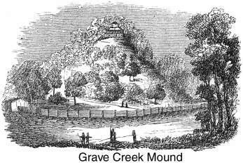
bank of the river. We had determined to stop here to inspect the
celebrated Grave Creek Mound; and, as the sun rose, passed through
the village, finding our way to the remains of this Indian monument.
"It is one of the largest," say Squier and Davis, "in
the Ohio Valley, measuring about seventy feet in height, by one
thousand in circumference at the base." It was excavated
in 1838 by sinking a shaft from its crown to its base, intersected
by a horizontal drift midway between them. Two sepulchral chambers
were found within—one at the base and the other thirty feet
above it, the lower containing two skeletons, the upper but one.
With these remains were found several thousand shell-beads, a
number of ornaments of mica, copper bracelets, and various articles
of carved stone. At the time of these discoveries the owner of
the mound built the wooden structure seen on the apex in the cut,
and used it as a sort of museum for the preservation of the relics.
But the structure is now open to the elements as well as visitors,
and is rapidly decaying; the Indian remains and ornaments have
been dispersed, and nothing is left but the gigantic tumulus and
the ancient trees that overshadow it.
We slept in
the cars on a "siding," near Cameron, about seventeen
miles from the Ohio, and when we woke next morning found that
our engineers and conductors had moved so silently from our resting-place
that we had been transferred insensibly to Moundville, on the
bank of the river. We had determined to stop here to inspect the
celebrated Grave Creek Mound; and, as the sun rose, passed through
the village, finding our way to the remains of this Indian monument.
"It is one of the largest," say Squier and Davis, "in
the Ohio Valley, measuring about seventy feet in height, by one
thousand in circumference at the base." It was excavated
in 1838 by sinking a shaft from its crown to its base, intersected
by a horizontal drift midway between them. Two sepulchral chambers
were found within—one at the base and the other thirty feet
above it, the lower containing two skeletons, the upper but one.
With these remains were found several thousand shell-beads, a
number of ornaments of mica, copper bracelets, and various articles
of carved stone. At the time of these discoveries the owner of
the mound built the wooden structure seen on the apex in the cut,
and used it as a sort of museum for the preservation of the relics.
But the structure is now open to the elements as well as visitors,
and is rapidly decaying; the Indian remains and ornaments have
been dispersed, and nothing is left but the gigantic tumulus and
the ancient trees that overshadow it.
On the twelve miles along the river-bank, between Moundville
and Wheeling, we observed the numerous structures which have arisen
in a few years in consequence of increased trade and travel. The
river margins on both sides of the Ohio River are almost continuous
villages, and, at Bellaire (on the Ohio side) and Benwood (on
the Virginia side), the internal improvements which lace so many
of the great Western States with their iron net-work seem to converge
for a vent over the mountains we had passed.
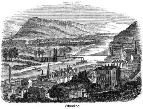 We passed rapidly
through Wheeling, where we would gladly have tarried to observe
the improvements of that thriving city, which has been the first
to span the Ohio with an iron bridge; but we were pressed for
time, and hardly able to reach the steamer which was to take us
to Pittsburg.
We passed rapidly
through Wheeling, where we would gladly have tarried to observe
the improvements of that thriving city, which has been the first
to span the Ohio with an iron bridge; but we were pressed for
time, and hardly able to reach the steamer which was to take us
to Pittsburg.
The day was hot and sultry as we ascended the river in a small
boat with the wind in our rear. We kept the deck stoutly, to see
the soft, rounded hills of the Ohio, with its lake-like reaches
and cultivated banks, dotted all over with farms, villages, and
homesteads. In the afternoon we stopped a moment at the mouth
of Yellow Creek to mark the site of the Indian massacre, where
Logan's kindred were slain; but in the quiet, grassy coves and
wooded slope where Baker's cabin stood, there were no tokens to
tell of the slaughter which, so long, and so unjustly, covered
the name of Cresap with infamy.
During our stay at Pittsburg, we drove out to Braddock's Battle-Field,
which is reached by a bad road along the river, about nine miles
above the city, on the Monongahela.
The sketch shows the field perfectly from the hills above it,
and exhibits the fine river-bend in front, with Turtle Creek Ford
(designated by the ripple on the left), where Braddock crossed
with his forces.
The Monongahela, at this spot, lies some two hundred or two
hundred and fifty feet below the surrounding hilltops. The banks
rise gradually from its margin to a wide-receding bottom, and,
above this, about fifty feet higher, another river-beach or bottom
slopes inward till the country rises abruptly into the steeper
summits of the basin. The levels have all been stripped for agriculture
and occupation, while the upper declivities are still crowned
with forest and understood. As the whole field has been denuded
for many years, its topography is, of course, laid entirely bare.
It is possible that travel and tillage, during the hundred years
that have elapsed since the battle, may have changed the surface,
but a careful inspection and subsequent survey do not 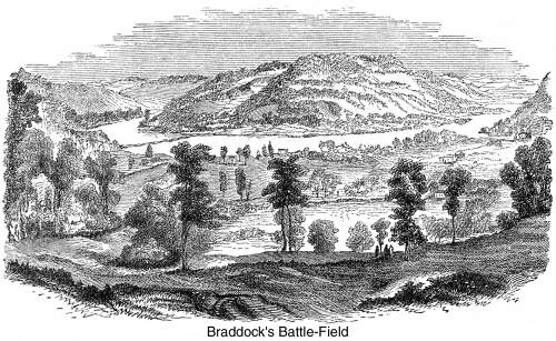 sustain the plans that were published
in England after the action. What are now mere depressions may
have been ravines a century ago, before the plow smoothed their
edges; but there seems to be hardly a doubt that Braddock, confident
in numbers and discipline, shamefully neglected to reconnoitre
the pass before he advanced up hill from the river into the wood.
In those days the field was covered with a forest. After fording
the Monongahela with his army, he began the march incautiously
toward Fort Duquesne. With drums beating, and colors flying, his
advance swept proudly and rashly up the steep into the thickets.
Rising diagonally from the first to the second level, it was suddenly
met by the French and savages, driven back on the centre, the
centre thrown back on the rear, which was dammed up by the river,
and the whole tumbled into utter confusion by the marksmen and
Indians who got possession of the flanking hillsides, and poured
down their merciless volleys upon the distracted crowd. Every
thing was hurled together by the impetuous and sustained onset,
till men, beasts, wagons, cannon, ammunition, and baggage became
little more than a swarming heap, pent up for slaughter. It is
not surprising, then, when one looks at the scene, in fancy, from
the field itself, that of the fourteen hundred and sixty who went
into battle, four hundred and fifty-six were slain, and four hundred
and twenty-one wounded. Truly has it been described as a "scene
of carnage unexampled in the annals of modern warfare."
sustain the plans that were published
in England after the action. What are now mere depressions may
have been ravines a century ago, before the plow smoothed their
edges; but there seems to be hardly a doubt that Braddock, confident
in numbers and discipline, shamefully neglected to reconnoitre
the pass before he advanced up hill from the river into the wood.
In those days the field was covered with a forest. After fording
the Monongahela with his army, he began the march incautiously
toward Fort Duquesne. With drums beating, and colors flying, his
advance swept proudly and rashly up the steep into the thickets.
Rising diagonally from the first to the second level, it was suddenly
met by the French and savages, driven back on the centre, the
centre thrown back on the rear, which was dammed up by the river,
and the whole tumbled into utter confusion by the marksmen and
Indians who got possession of the flanking hillsides, and poured
down their merciless volleys upon the distracted crowd. Every
thing was hurled together by the impetuous and sustained onset,
till men, beasts, wagons, cannon, ammunition, and baggage became
little more than a swarming heap, pent up for slaughter. It is
not surprising, then, when one looks at the scene, in fancy, from
the field itself, that of the fourteen hundred and sixty who went
into battle, four hundred and fifty-six were slain, and four hundred
and twenty-one wounded. Truly has it been described as a "scene
of carnage unexampled in the annals of modern warfare."
But a hundred years have obliterated every trace of the conflict.
Somewhat in the rear of the central house represented in the drawing
was the hottest part of the battle, for plowmen have found it
to be a perfect arsenal of balls, bullets, arrow-heads, and hatchets.
At present it is waving with grain; through the midst of it the
Pennsylvania Railroad has laid its iron track, and the yell of
the savage is exchanged for the shriek of the engine.