THE GRANITE TURNPIKE
The Turnpikes of New England—by
Frederic J. Wood—1919
The granite quarries of Quincy first came prominently before
the country when it was decided to construct the Bunker Hill Monument
from their product. They were four miles from tidewater, and the
only means of transporting the blocks of stone was over the roads
of that period, of which but a few miles tributary to the quarries
were turnpikes. To reach Boston required a roundabout journey
either by way of the Neponset Bridge or by way of Milton Lower
Mills, and there was no satisfactory way of reaching Charlestown,
where the monument was to be built. Hence a railway was conceived
by which the stones were carried down hill to the tidewater of
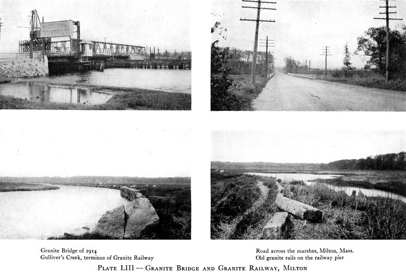
the Neponset River at Gulliver's Creek, where they were loaded
on to barges which were floated around to the dock in Charlestown.
This served very well as long as the stones were wanted at points
accessible by water, but an early demand arose for building stone
to be used in the new parts of Boston; and a more direct route
was needed.
April 13, 1837, the, proprietors of the Granite Bridge were
incorporated for the purpose of building a road from the old county
road at or near the store of I. Babcock, Jr., in Milton and running
thence north ten and three quarters degrees west, about two hundred
and seventy-two rods; north nineteen degrees west, about fifty-six
rods; north twentyfive and one half degrees west, about one hundred
and twenty-eight rods to the Neponset River, "and to locate,
build, and construct a bridge across said river in continuation
of said last-mentioned line of said road to Dorchester";
and thence to continue the road north eight and three quarters
degrees west, about one hundred and eight rods to the "lower
road" in Dorchester on or near the land of Rev. Ephraim Randall.
A draw not less than thirty-one feet wide was to be located by
commissioners appointed for that purpose, and wharves or piers
seventy-five feet long were to be built on each side to assist
vessels in passing through the opening. The total cost of bridge
and road was not to be in excess of fifteen thousand dollars and
the management was not allowed to incur annual expenses of over
fifteen hundred dollars.
Plotting the description of the route of the road plainly shows
that it began in the center of East Milton Village adjacent to
the crossing of the Granite Railway by Adams Street, the old county
road and the old colonial road to Plymouth. Thence it marked out
the lines of the present-day Granite Avenue across the marshes
and river to Adams Street in Dorchester, the "lower road."
This "lower road" was an ancient institution at that
date, having been an alternate route by which the bridge over
the Neponset at Milton Lower Mills was reached from Boston, the
other road passing through Grove Hall and following the Washington
Street of to-day. The "lower road" commenced at the
corner of Washington and Eustis streets near the boundary at that
date between Boston and Roxbury, and followed over what are now
known as Eustis, Mall, Dearborn, Dudley, Stoughton, Pleasant,
Bowdoin, Adams, and Washington streets to Milton Lower Mills.
At its beginning is found one of the oldest cemeteries in New
England, interments having begun there in 1633 and continued until
1854. At that point, also, was the first barricade erected by
the Americans to prevent the British troops from making a sortie
during the siege of Boston.
As the road built by the bridge company commenced almost on
the location of the Granite Railway and was only a few hundred
feet away from it at the railway's terminus, it may not be amiss
to consider here the cars and track which became so familiar to
the turnpike workmen. When the bridge and turnpike were built
the Granite Railway had been in operation about eleven years and
the railroads from Boston to Providence, Worcester, and. Lowell
about two years.
The track of the Granite Railway was originally composed of
stone crossties bedded in the ground at intervals of eight feet
with wooden rails faced with a bar of iron on which the wheels
ran. By 1837 the wooden rails had been replaced with stringers
of granite hammered smooth on the upper face and having similar
bars of iron pinned to their tops. It was officially stated that
the maintenance costs on this form of track had not amounted to
ten dollars a year, and the track continued in use until 1871,
when it was sold to the Old Colony Railroad Company and replaced
by a modern railroad construction. The first car had wheels six
and a half feet in diameter with the load carried on a platform
running just clear of the rails and hung from the axles by chains.
The capacity was about six tons.
In 1846 the Granite Railway Company was authorized to extend
its road, crossing the Neponset River not over five hundred feet
below the Granite toll bridge and uniting with the newly chartered
Dorchester and Milton Branch Railroad in Dorchester. It was also
given authority to sell its road to the Old Colony Railroad Company,
a privilege which was renewed in 1848 but which was not utilized
until 1871. Then the Old Colony introduced a curve in the track
at the foot of the hill on the edge of the marshes and carried
the track easterly along the southerly bank of the river to a
junction with its main line at Atlantic. The section running out
over the marsh and the pier at Gulliver's Creek were thus left
out of the reckoning, but the pier is still to be plainly traced,
and on it can be seen to-day about two hundred feet of the old
granite rails still in the place where they carried the cars of
stone. The iron plates which received the tread of the wheels
are gone but rust clearly shows where they were, and the pins
which held them are yet in place.
It would seem that the drivers of teams which passed over the
Granite Bridge were not satisfied with the capacity of the railway
car, for the company was obliged to ask the passage of an act
in 1845 by which the owner of a load of over seven tons was made
liable for any damage done to the bridge.
With Yankee shrewdness the company reported the bridge and
road as costing fifteen thousand dollars, all that the law allowed,
which does not seem to have been an unreasonable figure. There
was considerable difficult construction of the road across the
soft marsh and the bridge abutments must have been costly to build.
The corporation made returns of business from 1840 to 1854, but
complete for only eleven years. For those years the net earnings
were about three hundred and seventeen dollars on an average,
or two and eleven hundredths per cent. The gross receipts ran
from five hundred and fifty to fifteen hundred dollars, but generally
around seven or eight hundred. In one year only, 1852, was a loss
reported when the business ran behind to the amount of three hundred
and sixty-three dollars.
May 4, 1865, the Norfolk county commissioners were authorized
to lay out the bridge and road as a public highway. The property
had fallen into a bad condition and the commissioners were required
to put the same into proper repair, after which the towns of Dorchester
and Milton were to assume the maintenance. The commissioners,
under that authority, laid out the road and bridge September 8,
1865.
The present bridge was in part built under the provisions of
an act passed June 13, 1913, by which a commission was provided
for the purpose of constructing a new bridge with suitable approaches,
substantially replacing the old bridge. Seventy thousand dollars
was to be advanced by the Commonwealth to be repaid later by Suffolk
and Norfolk counties, Milton, and Quincy. The control is now vested
in the mayor of Boston and the chairman of the selectmen of Milton.
We have previously noted the effort to build a road by the
Tyringham and Sandisfield Turnpike Corporation and concluded that
the effort was in vain. In 1841, February 27, the Clam River Turnpike
Corporation was formed to carry out the same purpose. The route
allowed this company was from New Boston in Sandisfield to Hubbard's
cider mill in Tyringham, following up the Clam River and down
Hop Brook. At the date of this charter there were several railroads
actually built and in operation in Massachusetts, and the builders
of the Western Railroad were then cleaving the Berkshires. The
day of the turnpike had passed with the demonstration of the success
of the locomotive, and this corporation was born too late. Not
even a location by a committee of the court was secured and the
whole enterprise faded away.
That there was some need of a road in the route specified is
evident from the fact that the local authorities later did build
a public road between West Otis and Tryingham on the line allowed
the Clam River Corporation.
Twenty-seven years later, March 23, 1868, the Chelsea Beach
and Saugus Bridge and Turnpike Company was incorporated, the last
in Massachusetts. Its proposed road was to lead from the Ocean
House in North Chelsea, now Revere, to the Salem Turnpike in Saugus
opposite the junction with the Saugus Road. Apparently this road
was to be about a mile long, starting at the outer end of the
Point of Pines, and running straight, as was a turnpike's wont,
across the marshes to the Salem Turnpike near the Saugus and Lynn
boundary. It does not appear that anything beyond securing the
charter was ever done.
Although the turnpike era was long past, this corporation does
not altogether stand alone. Its purpose plainly was to give entrance
to a pleasure resort, and many similar turnpike charters are found
on the New Hampshire legislative records at the same and later
dates, providing for roads to the summits of several of the noted
mountains of that state.
This page originally appeared on Thomas Ehrenreich's Railroad Extra Website