The TRAIL of the IRON HORSE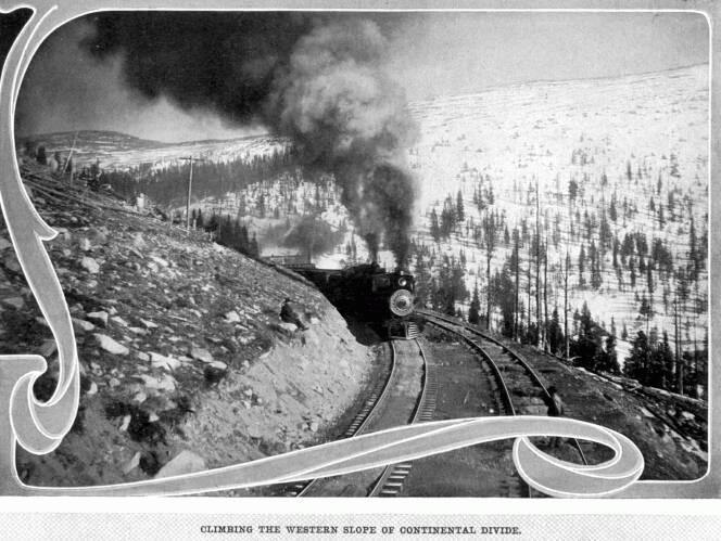
A Trip Over the Continental Divide of the Rocky Mountains
(by the Moffat Line)
OBSERVATIONS ON THE WAY
ON leaving Denver, the train passes almost immedately into
the beautiful Clear Creek Valley, noted for its well-kept ranches,
on which, by means of irrigation, fruit and vegetables are raised
for the Denver market. A short distance beyond Leyden, with its
coal mines, the ascent of the foothills is commenced, as a preliminary
to the final climb to Rollins Pass, at an elevation of 11,666
feet, which is the lowest depression in the great Continental
Divide, sometimes called "The Backbone of the Continent."
The first object of interest now is the "Rainbow"
cut, through which the train passes just this side of Plainview
Station, where the first general panorama of the plains appears.
There are now thirty-four tunnels, most of them very short, through
which we must pass before reaching the summit, No. 30, the shortest,
being but seventy-five feet long, and No. 18, the longest, 1,729
feet, or about one-third of a mile. The view of the plains from
Tunnel No. 8 is perhaps the most enchanting of any, and from tunnel
No. 17, looking backward toward No. 8, is perhaps the best view
of the tunnels themselves. The elevation of Tunnel No. 24 is 7,611
feet, that of Denver being 5,170 feet. A large slab of rock that
fell near Tunnel No. 29, as the result of a heavy charge of dynamite,
and which barely escaped crushing the road builders, can be seen
from the train.
After passing the lower group of tunnels, the train reaches
Gato Station Canon, the widest and prettiest part of the gorge,
just thirty-seven miles from Denver. Next comes Pactolus Station,
showing where the placer mines have been worked; and then the
town of Rollinsville, where there is a stage line to Eldora, a
noted mining camp seven miles away. Next comes Boulder Park, and
a little further on Tolland Station, with its pretty lake and
wild flowers, fifty miles from Denver, at an elevation of 8,889
feet.
Here the train commences its steepest climb, a four per cent
grade, and directs its way toward James Peak, one of the sentinels
of the Rockies, from which it winds and curves first to the right
and then to the left, continually rising until the pretty park
below, diminishing in size as distance increases, becomes a mere
dot upon the landscape.
From a water tank just past Antelope Station we see tile snow
sheds near the top of the pass, and obtain a remarkably fine view.
Again, west of Tunnel No. 33, which is another fine view, showing
the banks of perpetual snow near the top of the range.
The view from jenny Lake shows the wonderfully steep grade
of the railroad, and also the mountains of rock and slate, grandeur
upon grandeur, with the "Arapahoes" on the right and
James Peak to the left.
The summit is reached sixty-five miles from Denver, and then
commences the decline on the western slope of the Continental
Divide, where the streams find their outlet in the Gulf of California.
Far to the west we see the Rabbit Ear range of mountains in
the distance. Four miles below the summit we reach Loop Siding,
where the train crosses itself in its various windings, and then
passes through the beautiful forest of pines, where the trees
are so thick as to almost exclude the sunlight.
In a short time the train stops at Arrowhead, from which place
the beautiful vista of James Peak from its west side is shown
through the trees. The road is now being graded to Hot Sulphur
Springs, which, it is expected, will be reached July 1st, and
from there it will be extended through Gore Canon and on to Salt
Lake City.
From Sea to
Shining Sea | Contents Page
|